Rhode Island
Reproductions of old maps of cities, towns and villages in Rhode Island, from the 1870 Beers Atlas of the State of Rhode Island.
Most town maps show the property owner's name on each house. Also shown: schools, churches, shops and factories, saw- and grist-mills, railroad tracks and stations, livery stables, etc. These maps are full of interesting facts for genealogists and local historians.
| Products |
|---|
|
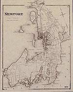
Newport map
This historical town map of Newport, Rhode Island (RI), is reprinted from the 1870 Atlas of the State of Rhode Island (RI), published by D. G. Beers. (Includes Coddington Cove, Coaster's Harbor Island, Rose Island, Goat Island, Gull Rocks, Bishop Rock, Lime Rock Light, Fort Adams, Castle Hill, Graves Point, Gooseberry Island, Coggeshalls Ledge, Easton's Pond, Easton's Beach, Almy's Pond, Lily Pond, etc.)
$15.00 - $21.00
|
|
|
 Old Maps of New England & New York


