Frequently Asked Questions
Where do these reproductions of antique maps come from?
Most of the maps are reproduced from county atlases published between 1864 and 1900. Before the 1860s, county wall maps were popular, but the book form had many advantages over the huge wall maps. In New England, county atlases are often referred to as "Beers atlases," because the Beers family produced many of the region's atlases.
Excerpt from American Maps and Mapmakers by Walter W. Ristow: "A large percentage of the eastern county atlases were published by members of the Beers family. Silas Beers, Daniel Beers, and their assistants collaborated on a survey of Jefferson County, New York, the results of which were published in an atlas of C. K. Stone in 1864. Beers established his own publishing company, Dnaiel G. Beers & Co., at 95 Maiden Lane in New York in 1868. ... Between 1864 and 1885 the several members of the Beers family, singly or in association with each other and other surveyors and publishers, produced more than 125 atlases, most of them for counties in the New England and Middle Atlantic states. Beers family members also surveyed or published more than 50 county land ownership maps."
Prices?
Maps are $15.00 without a mat, or $21.00 matted. Town descriptions (Gazetteer Excerpts) are $10.00 without a mat, or $16.00 matted.
Choosing between a town map and a village map:
When a part of a town was thickly settled, leaving insufficient space on the map for the family names to be written beside each house, a blow-up or inset map was usually made of that area. Sometimes it is incorporated into the same page as the town map; or it could be on another page. For instance, Map MAW16 shows the entire towns of Templeton and Phillipston, Massachusetts. But Map MAW17 shows detail maps of Phillipston Centre, and map MAW18 includes detail maps of East Phillipston. Check the map list carefully to be sure which map you want. At fairs, when people get to see the maps, town maps outsell village maps by twenty to one.
What are:
Gazetteer Excerpts?
Also called Town Descriptions?
Town Descriptions are excerpts from antique gazetteers written in the 1800s, describing the towns of New England and New York. They are typeset in attractive old typefaces, reproduced on modern parchment 8.5 by 11 inches. They are available matted in 11 by 14 inch acid-free mats, which fit a standard size frame. These gazetteer excerpts give information such as the location of the town, the tax rate, names of hills and streams, number of dwelling houses and church edifices, the origin of the town name, information about local industry and agriculture, etc. Each town's gazetteer was written by a different author, so the style varies from state to state.
Map size and color?
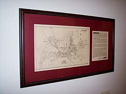
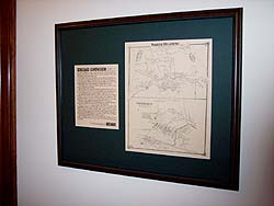
Historical Ink's reproductions of antique maps are reprinted in black ink on natural-color parchment, slightly reduced in size from the originals. Most are between 11 by 14 inches and 11 by 16 inches. All are available unmatted or matted in acid-free 16 by 20 inch mats which fit a standard size frame. Mat color choices are: Forest Green, Navy Blue, Brick Red (dark red), or Black. If you are giving a map for a gift, having it matted makes it look much more attractive (unless you are sure the recipient will be putting it in a scrapbook or a genealogy file cabinet ...)
Shipping information:
Shipping charges (USPS):
Within the United States: $10.00 for the first item, plus $1.00 for each additional item. (All orders are sent by the U.S. Postal Service.) All map orders to U.S. addresses (whether matted or unmatted) are shipped flat.
International charges: International orders are shipped rolled in a tube, $30.00 for the first item, plus 1.50 cents for each additional item. (We hate to roll maps, but shipping large flat packages overseas is incredibly expensive!)
Allow 3 to 4 weeks for delivery (but we ship within 3 business days in December!).
Who loves antique maps?
These old maps are of particular interest to genealogists, because if you can find your family's name on a vintage map, you will be able to see the names of their neighbors, how far they lived from a post office or store, and other details of their lives. Other map buyers are local historians, metal-detector treasure hunters, owners of old houses or businesses, railroad historians, postal historians, bikers and hikers, town officials and employees, history teachers, and many others. Some people have framed the town map (or the map and town description together) to make a great retirement present for a town employee or for display in a new business. Old maps are interesting wall decorations for a doctor's or lawyer's waiting room. Homeowners often buy old maps so they can see the changes that have occurred in the town they love.
Matting a Map and Town Description Together
To do this, order the map and town description unmatted, and take them to a local frame shop. Because some maps are tall and some are wide, and the town descriptions also vary slightly in size, it is not possible for us to offer these items matted together. Putting them both in the same frame creates a handsome presentation piece. We have seen this idea used as a retirement gift, as a gift for a new professional office, as decor in a restaurant, etc.
|


