Rhode Island
Reproductions of old maps of cities, towns and villages in Rhode Island, from the 1870 Beers Atlas of the State of Rhode Island.
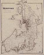
Most town maps show the property owner's name on each house. Also shown: schools, churches, shops and factories, saw- and grist-mills, railroad tracks and stations, livery stables, etc. These maps are full of interesting facts for genealogists and local historians.
| Products |
|---|
|
This map is reprinted from the 1870 Atlas of the State of Rhode Island (RI), published by D. G. Beers
$15.00 - $21.00
|
|
|
 Old Maps of New England & New York


