Connecticut
Reproductions of old maps of towns and villages in Connecticut, from county atlases published in the late 1800s. Most maps show the family name on each house.
Also shown: schools, factories, railroad tracks and stations, churches, saw- and grist-mills, etc. Maps are available from these county atlases:
Old New London County maps from the Atlas of New London County, published in 1868 by Beers, Ellis & Soule
Old New Haven County maps from the Atlas of New Haven County, published in 1868 by F. W. Beers
Old Old Hartford County maps from the Atlas of Hartford & Tolland Counties, published in 1869 by Baker & Tilden
Old Tolland County maps from the Atlas of Hartford & Tolland Counties, published in 1869 by Baker & Tilden
Old Litchfield County maps from the Atlas of Litchfield County, published in 1874 by F. W. Beers
Old Fairfield County maps from the Atlas of New York & Vicinity, published in 1867 by Beers, Ellis & Soule
Old Middlesex County maps, from the Atlas of Middlesex County, published in 1874 by F. W. Beers
Old Windham County maps from the Atlas of Windham County, published in 1869 by Gray
| Categories |
|---|
Maps for Genealogy: Old maps of Fairfield County towns, reproduced from the Atlas of new York & Vicinity, published in 1867 by Beers, Ellis & Soule.
|
|
|
|
|
|
|
Old maps of New London County towns
|
|
|
|
|
| Products |
|---|
|
North Branford map
This historical North Branford map was reproduced from the Atlas of New Haven County, Connecticut (CT), published in 1868 by F. W. Beers.
$15.00 - $21.00
|
|
Seymour map
This historical Seymour town map was reproduced from the Atlas of New Haven County, Connecticut (CT), published in 1868 by F. W. Beers.
$15.00 - $21.00
|
|
This historical old map of Seymour village was reproduced from the Atlas of New Haven County, Connecticut (CT), 1868, by F. W. Beers
$15.00 - $21.00
|
|
Bethany map
This historical Bethany map was reproduced from the Atlas of New Haven County, Connecticut (CT), published in 1868 by F. W. Beers.
$15.00 - $21.00
|
|
Oxford map
This historical Oxford map was reproduced from the Atlas of New Haven County, Connecticut (CT), published in 1868 by F. W. Beers.
$15.00 - $21.00
|
|
Naugatuck map
This historical Naugatuck map was reproduced from the Atlas of New Haven County, Connecticut (CT), published in 1868 by F. W. Beers.
$15.00 - $21.00
|
|
Prospect map
This historical Prospect map was reproduced from the Atlas of New Haven County, Connecticut (CT), published in 1868 by F. W. Beers.
$15.00 - $21.00
|
|
Reproduced from the Atlas of New Haven County, Connecticut (CT), 1868, by F. W. Beers
$15.00 - $21.00
|
|
Cheshire map
This historical Cheshire map was reproduced from the Atlas of New Haven County, Connecticut (CT), published in 1868 by F. W. Beers.
$15.00 - $21.00
|
|
Reproduced from the Atlas of New Haven County, Connecticut (CT), 1868, by F. W. Beers
$15.00 - $21.00
|
|
Wallingford map
This historical Wallingford map was reproduced from the Atlas of New Haven County, Connecticut (CT), published in 1868 by F. W. Beers.
$15.00 - $21.00
|
|
Reproduced from the Atlas of New Haven County, Connecticut (CT), 1868, by F. W. Beers
$15.00 - $21.00
|
|
Meriden map
This historical Meriden map was reproduced from the Atlas of New Haven County, Connecticut (CT), published in 1868 by F. W. Beers.
$15.00 - $21.00
|
This historical Meriden map was reproduced from the Atlas of New Haven County, Connecticut (CT), published in 1868 by F. W. Beers. (No family names) $15.00 - $21.00
|
|
Southbury map
This historical Southbury map was reproduced from the Atlas of New Haven County, Connecticut (CT), published in 1868 by F. W. Beers.
$15.00 - $21.00
|
|
Reproduced from the Atlas of New Haven County, 1868, by F. W. Beers
$15.00 - $21.00
|
|
Middlebury map
This historical Middlebury map was reproduced from the Atlas of New Haven County, Connecticut (CT), published in 1868 by F. W. Beers.
$15.00 - $21.00
|
|
Waterbury map
This historical Waterbury map was reproduced from the Atlas of New Haven County, Connecticut (CT), published in 1868 by F. W. Beers.
$15.00 - $21.00
|
|
Reproduced from the Atlas of New Haven County, Connecticut (CT), 1868, by F. W. Beers
$15.00 - $21.00
|
|
Wolcott map
This historical Wolcott map was reproduced from the Atlas of New Haven County, Connecticut (CT), published in 1868 by D. G. Beers.
$15.00 - $21.00
|
|
Historical map of New London County, Connecticut (CT), reproduced from the Atlas of New London County, Connecticut (CT), 1868, by Beers, Ellis & Soule.
$15.00 - $21.00
|
|
Historical town map of Colchester, Connecticut (CT), reproduced from the Atlas of New London County, Connecticut (CT), 1868, by Beers, Ellis & Soule.
$15.00 - $21.00
|
|
Historical old Colchester village map, reproduced from the Atlas of New London County, Connecticut (CT), 1868, by Beers, Ellis & Soule
$15.00 - $21.00
|
|
Historical town map of Lebanon, Connecticut (CT), reproduced from the Atlas of New London County, Connecticut (CT), 1868, by Beers, Ellis & Soule
$15.00 - $21.00
|
|
Historical town map of Franklin, Connecticut (CT), reproduced from the Atlas of New London County, 1868, by Beers, Ellis & Soule.
$15.00 - $21.00
|
|
Historical town map of Sprague, Connecticut (CT), reproduced from the Atlas of New London County, Connecticut (CT), 1868, by Beers, Ellis & Soule.
$15.00 - $21.00
|
|
Historical town map of Lisbon, Connecticut (CT), reproduced from the Atlas of New London County, 1868, by Beers, Ellis & Soule.
$15.00 - $21.00
|
|
Griswold map
Historical town map of Griswold, Connecticut (CT), reproduced from the Atlas of New London County, 1868, by Beers, Ellis & Soule.
$15.00 - $21.00
|
|
Bozrah map
Historical town map of Bozrah, Connecticut (CT), reproduced from the Atlas of New London County, 1868, by Beers, Ellis & Soule.
$15.00 - $21.00
|
|
Norwich map
Historical town map of Norwich and the village of Yantic, Connecticut (CT), reproduced from the Atlas of New London County, 1868, by Beers, Ellis & Soule.
$15.00 - $21.00
|
|
Reproduced from the Atlas of New London County, 1868, by Beers, Ellis & Soule.
$15.00 - $21.00
|
|
Reproduced from the Atlas of New London County, 1868, by Beers, Ellis & Soule
$15.00 - $21.00
|
|
This historical old Bean Hill and Norwich Town map is reproduced from the Atlas of New London County, Connecticut (CT), 1868, by Beers, Ellis & Soule
$15.00 - $21.00
|
|
Preston map
Historical town map of Preston, Connecticut (CT), reproduced from the Atlas of New London County, Connecticut (CT), 1868, by Beers, Ellis & Soule.
$15.00 - $21.00
|
|
Salem map
Historical town map of Salem, Connecticut (CT), reproduced from the Atlas of New London County, 1868, by Beers, Ellis & Soule
$15.00 - $21.00
|
|
Montville map
Historical town map of Montville, Connecticut (CT), with the villages of Uncasville and Montville, reproduced from the Atlas of New London County, 1868, by Beers, Ellis & Soule.
$15.00 - $21.00
|
|
Ledyard map
Historical town map of Ledyard, Connecticut (CT), reproduced from the Atlas of New London County, 1868, by Beers, Ellis & Soule.
$15.00 - $21.00
|
|
North Stonington map
Historical town map of North Stoningham, Connecticut (CT), reproduced from the Atlas of New London County, 1868, by Beers, Ellis & Soule. Family names are shown on most houses. Billings Lake, Syassup Lake, Stewart Hill, Lond Pond, spalding Pond, Oak Grove, Laurel Glen, Clarke's Falls, Pitcher's Mountain, Cossaduck Hill, Alder Brook, Prentice Mountain, Lantern Hill, Hill Pond and Long Hill are shown.
$15.00 - $21.00
|
|
Lyme map, Connecticut
Historical town map of Lyme, Connecticut (CT), reproduced from the Atlas of New London County, 1868, by Beers, Ellis & Soule
$15.00 - $21.00
|
|
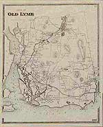
Old Lyme map
Historical town map of Old Lyme, Connecticut (CT), reproduced from the Atlas of New London County, 1868, by Beers, Ellis & Soule. The map shows family names on most houses. Rogers Lake, Black Hall Pond, Lords Cove, Goose Island, Calves Island, North and South Cove, Saybrook Light House, Black Hall Griswold's Point, Black Hall River, and Matchett's Point are shown.
$15.00 - $21.00
|
|
East Lyme map
Historical town map of East Lyme, Connecticut (CT), reproduced from the Atlas of New London County, 1868, by Beers, Ellis & Soule.
$15.00 - $21.00
|
|
Waterford map
Historical town map of Waterford, Connecticut (CT), reproduced from the Atlas of New London County, 1868, by Beers, Ellis & Soule.
$15.00 - $21.00
|
|
New London map
Historical city map of the southern part of the city of New London, reproduced from the Atlas of New London County, Connecticut (CT), 1868, by Beers, Ellis & Soule.
$15.00 - $21.00
|
|
Reproduced from the Atlas of New London County, 1868, by Beers, Ellis & Soule. This item is a list of New County City businesses, city officers, etc.
$15.00 - $21.00
|
|
Groton map
Historical town map of Groton, Connecticut (CT), reproduced from the Atlas of New London County, 1868, by Beers, Ellis & Soule.
$15.00 - $21.00
|
|
Reproduced from the Atlas of New London County, 1868, by Beers, Ellis & Soule
$15.00 - $21.00
|
|
Mystic River map
Historical village map of Mystic River, Connecticut (CT), reproduced from the Atlas of New London County, 1868, by Beers, Ellis & Soule.
$15.00 - $21.00
|
|
Reproduced from the Atlas of New London County, 1868, by Beers, Ellis & Soule
$15.00 - $21.00
|
|
Stonington map
Historical town map of Stonington, Connecticut (CT), reproduced from the Atlas of New London County, 1868, by Beers, Ellis & Soule
$15.00 - $21.00
|
|
Reproduced from the Atlas of New London County, 1868, by Beers, Ellis & Soule
$15.00 - $21.00
|
|
|
 Old Maps of New England & New York


