New London County Maps
Reproduced from the 1868 Atlas of New London Countym, published by Beers, Ellis & Soule.
1868 Map of East Lyme
New London County, CT
| Products |
|---|
|
Historical map of New London County, Connecticut (CT), reproduced from the Atlas of New London County, Connecticut (CT), 1868, by Beers, Ellis & Soule.
$15.00 - $21.00
|
|
Historical town map of Colchester, Connecticut (CT), reproduced from the Atlas of New London County, Connecticut (CT), 1868, by Beers, Ellis & Soule.
$15.00 - $21.00
|
|
Historical old Colchester village map, reproduced from the Atlas of New London County, Connecticut (CT), 1868, by Beers, Ellis & Soule
$15.00 - $21.00
|
|
Historical town map of Lebanon, Connecticut (CT), reproduced from the Atlas of New London County, Connecticut (CT), 1868, by Beers, Ellis & Soule
$15.00 - $21.00
|
|
Historical town map of Franklin, Connecticut (CT), reproduced from the Atlas of New London County, 1868, by Beers, Ellis & Soule.
$15.00 - $21.00
|
|
Historical town map of Sprague, Connecticut (CT), reproduced from the Atlas of New London County, Connecticut (CT), 1868, by Beers, Ellis & Soule.
$15.00 - $21.00
|
|
Historical town map of Lisbon, Connecticut (CT), reproduced from the Atlas of New London County, 1868, by Beers, Ellis & Soule.
$15.00 - $21.00
|
|
Griswold map
Historical town map of Griswold, Connecticut (CT), reproduced from the Atlas of New London County, 1868, by Beers, Ellis & Soule.
$15.00 - $21.00
|
|
Bozrah map
Historical town map of Bozrah, Connecticut (CT), reproduced from the Atlas of New London County, 1868, by Beers, Ellis & Soule.
$15.00 - $21.00
|
|
Norwich map
Historical town map of Norwich and the village of Yantic, Connecticut (CT), reproduced from the Atlas of New London County, 1868, by Beers, Ellis & Soule.
$15.00 - $21.00
|
|
Reproduced from the Atlas of New London County, 1868, by Beers, Ellis & Soule.
$15.00 - $21.00
|
|
Reproduced from the Atlas of New London County, 1868, by Beers, Ellis & Soule
$15.00 - $21.00
|
|
This historical old Bean Hill and Norwich Town map is reproduced from the Atlas of New London County, Connecticut (CT), 1868, by Beers, Ellis & Soule
$15.00 - $21.00
|
|
Preston map
Historical town map of Preston, Connecticut (CT), reproduced from the Atlas of New London County, Connecticut (CT), 1868, by Beers, Ellis & Soule.
$15.00 - $21.00
|
|
Salem map
Historical town map of Salem, Connecticut (CT), reproduced from the Atlas of New London County, 1868, by Beers, Ellis & Soule
$15.00 - $21.00
|
|
Montville map
Historical town map of Montville, Connecticut (CT), with the villages of Uncasville and Montville, reproduced from the Atlas of New London County, 1868, by Beers, Ellis & Soule.
$15.00 - $21.00
|
|
Ledyard map
Historical town map of Ledyard, Connecticut (CT), reproduced from the Atlas of New London County, 1868, by Beers, Ellis & Soule.
$15.00 - $21.00
|
|
North Stonington map
Historical town map of North Stoningham, Connecticut (CT), reproduced from the Atlas of New London County, 1868, by Beers, Ellis & Soule. Family names are shown on most houses. Billings Lake, Syassup Lake, Stewart Hill, Lond Pond, spalding Pond, Oak Grove, Laurel Glen, Clarke's Falls, Pitcher's Mountain, Cossaduck Hill, Alder Brook, Prentice Mountain, Lantern Hill, Hill Pond and Long Hill are shown.
$15.00 - $21.00
|
|
Lyme map, Connecticut
Historical town map of Lyme, Connecticut (CT), reproduced from the Atlas of New London County, 1868, by Beers, Ellis & Soule
$15.00 - $21.00
|
|
Old Lyme map
Historical town map of Old Lyme, Connecticut (CT), reproduced from the Atlas of New London County, 1868, by Beers, Ellis & Soule. The map shows family names on most houses. Rogers Lake, Black Hall Pond, Lords Cove, Goose Island, Calves Island, North and South Cove, Saybrook Light House, Black Hall Griswold's Point, Black Hall River, and Matchett's Point are shown.
$15.00 - $21.00
|
|
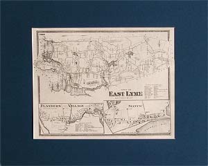
East Lyme map
Historical town map of East Lyme, Connecticut (CT), reproduced from the Atlas of New London County, 1868, by Beers, Ellis & Soule.
$15.00 - $21.00
|
|
Waterford map
Historical town map of Waterford, Connecticut (CT), reproduced from the Atlas of New London County, 1868, by Beers, Ellis & Soule.
$15.00 - $21.00
|
|
New London map
Historical city map of the southern part of the city of New London, reproduced from the Atlas of New London County, Connecticut (CT), 1868, by Beers, Ellis & Soule.
$15.00 - $21.00
|
|
Reproduced from the Atlas of New London County, 1868, by Beers, Ellis & Soule. This item is a list of New County City businesses, city officers, etc.
$15.00 - $21.00
|
|
Groton map
Historical town map of Groton, Connecticut (CT), reproduced from the Atlas of New London County, 1868, by Beers, Ellis & Soule.
$15.00 - $21.00
|
|
Reproduced from the Atlas of New London County, 1868, by Beers, Ellis & Soule
$15.00 - $21.00
|
|
Mystic River map
Historical village map of Mystic River, Connecticut (CT), reproduced from the Atlas of New London County, 1868, by Beers, Ellis & Soule.
$15.00 - $21.00
|
|
Reproduced from the Atlas of New London County, 1868, by Beers, Ellis & Soule
$15.00 - $21.00
|
|
Stonington map
Historical town map of Stonington, Connecticut (CT), reproduced from the Atlas of New London County, 1868, by Beers, Ellis & Soule
$15.00 - $21.00
|
|
Reproduced from the Atlas of New London County, 1868, by Beers, Ellis & Soule
$15.00 - $21.00
|
|
Voluntown map
Historical town map of Voluntown, Connecticut (CT), reproduced from the Atlas of Windham County, Connecticut (CT), published by Gray in 1869.
$15.00 - $21.00
|
|
|
 Old Maps of New England & New York


