|
This historical old Marlborough map is reproduced from the Atlas of Hartord & Tolland Counties, , Connecticut (CT)published in 1869 by Baker & Tilden.
$15.00 - $21.00
|
|
This historical old Glastonbury map is reproduced from the Atlas of Hartord & Tolland Counties, , Connecticut (CT)published in 1869 by Baker & Tilden.
$15.00 - $21.00
|
|
Reproduced from the Atlas of Hartord & Tolland Counties, , Connecticut (CT)published in 1869 by Baker & Tilden.
$15.00 - $21.00
|
|
This historical old Manchester map is reproduced from the Atlas of Hartord & Tolland Counties, Connecticut (CT), published in 1869 by Baker & Tilden.
$15.00 - $21.00
|
|
Reproduced from the Atlas of Hartord & Tolland Counties, Connecticut (CT), published in 1869 by Baker & Tilden.
$15.00 - $21.00
|
|
Reproduced from the Atlas of Hartord & Tolland Counties, Connecticut (CT), published in 1869 by Baker & Tilden.
$15.00 - $21.00
|
|
Reproduced from the Atlas of Hartord & Tolland Counties, Connecticut (CT), published in 1869 by Baker & Tilden.
$15.00 - $21.00
|
|
This historical old East Hartford map is reproduced from the Atlas of Hartord & Tolland Counties, Connecticut (CT), published in 1869 by Baker & Tilden.
$15.00 - $21.00
|
|
This historical old South Windsor map is reproduced from the Atlas of Hartord & Tolland Counties, Connecticut (CT), published in 1869 by Baker & Tilden.
$15.00 - $21.00
|
|
1869 map of Hartford County, Tolland County and Middlesex County, showing part of New Haven County ... a section of the map of the state of Connecticut from the 1869 Baker & Tilden Atlas.
$15.00 - $21.00
|
|
This historical old East Windsor map is reproduced from the Atlas of Hartord & Tolland Counties, Connecticut (CT), published in 1869 by Baker & Tilden.
$15.00 - $21.00
|
|
Reproduced from the Atlas of Hartord & Tolland Counties, Connecticut (CT), published in 1869 by Baker & Tilden.
$15.00 - $21.00
|
|
This historical old Enfield map is reproduced from the Atlas of Hartord & Tolland Counties, Connecticut (CT), published in 1869 by Baker & Tilden.
$15.00 - $21.00
|
|
Reproduced from the Atlas of Hartord & Tolland Counties, published in 1869 by Baker & Tilden.
$15.00 - $21.00
|
|
This historical old Hazardville map is reproduced from the Atlas of Hartord & Tolland Counties, Connecticut (CT), published in 1869 by Baker & Tilden.
$15.00 - $21.00
|
|
This historical old Suffield map is reproduced from the Atlas of Hartord & Tolland Counties, Connecticut (CT), published in 1869 by Baker & Tilden.
$15.00 - $21.00
|
|
This historical old Windsor Locks map is reproduced from the Atlas of Hartord & Tolland Counties, Connecticut (CT), published in 1869 by Baker & Tilden.
$15.00 - $21.00
|
|
Reproduced from the Atlas of Hartord & Tolland Counties, published in 1869 by Baker & Tilden.
$15.00 - $21.00
|
|
This historical old Windsor map is reproduced from the Atlas of Hartord & Tolland Counties, Connecticut (CT), published in 1869 by Baker & Tilden.
$15.00 - $21.00
|
|
This historical old Windsor map is reproduced from the Atlas of Hartord & Tolland Counties, Connecticut (CT), published in 1869 by Baker & Tilden.
$15.00 - $21.00
|
|
This historical old Hartford map is reproduced from the Atlas of Hartord & Tolland Counties, Connecticut (CT), published in 1869 by Baker & Tilden.
$15.00 - $21.00
|
|
This historical old Wethersfield map is reproduced from the Atlas of Hartord & Tolland Counties, Connecticut (CT), published in 1869 by Baker & Tilden.
$15.00 - $21.00
|
|
This historical old Wethersfield map is reproduced from the Atlas of Hartord & Tolland Counties, Connecticut (CT), published in 1869 by Baker & Tilden.
$15.00 - $21.00
|
|
Reproduced from the Atlas of Hartord & Tolland Counties, published in 1869 by Baker & Tilden.
$15.00 - $21.00
|
|
This historical old Berlin map is reproduced from the Atlas of Hartord & Tolland Counties, Connecticut (CT), published in 1869 by Baker & Tilden.
$15.00 - $21.00
|
|
This historical old New Britain map is reproduced from the Atlas of Hartord & Tolland Counties, Connecticut (CT), published in 1869 by Baker & Tilden.
$15.00 - $21.00
|
|
This historical old New Britain map is reproduced from the Atlas of Hartord & Tolland Counties, Connecticut (CT), published in 1869 by Baker & Tilden.
$15.00 - $21.00
|
|
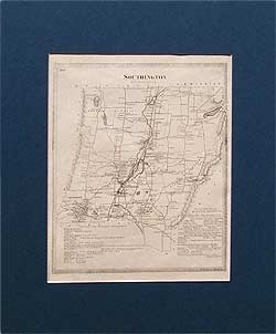
This historical old Southingtonmap was reproduced from the Atlas of Hartord & Tolland Counties, Connecticut (CT), published in 1869 by Baker & Tilden.
$15.00 - $21.00
|
|
Reproduced from the Atlas of Hartord & Tolland Counties, published in 1869 by Baker & Tilden.
$15.00 - $21.00
|
|
Reproduced from the Atlas of Hartord & Tolland Counties, published in 1869 by Baker & Tilden.
$15.00 - $21.00
|
|
This historical old Farmington map is reproduced from the Atlas of Hartord & Tolland Counties, Connecticut (CT), published in 1869 by Baker & Tilden.
$15.00 - $21.00
|
|
Reproduced from the Atlas of Hartord & Tolland Counties, published in 1869 by Baker & Tilden.
$15.00 - $21.00
|
|
Reproduced from the Atlas of Hartord & Tolland Counties, published in 1869 by Baker & Tilden.
$15.00 - $21.00
|
|
This historical old West Hartford map is reproduced from the Atlas of Hartord & Tolland Counties, Connecticut (CT), published in 1869 by Baker & Tilden.
$15.00 - $21.00
|
|
This historical old Bloomfield map is reproduced from the Atlas of Hartord & Tolland Counties, Connecticut (CT), published in 1869 by Baker & Tilden.
$15.00 - $21.00
|
|
This historical old East Granby map is reproduced from the Atlas of Hartord & Tolland Counties, Connecticut (CT), published in 1869 by Baker & Tilden.
$15.00 - $21.00
|
|
This historical old Granby map is reproduced from the Atlas of Hartord & Tolland Counties, Connecticut (CT), published in 1869 by Baker & Tilden.
$15.00 - $21.00
|
|
This historical old Hartland map is reproduced from the Atlas of Hartord & Tolland Counties, Connecticut (CT), published in 1869 by Baker & Tilden.
$15.00 - $21.00
|
|
This historical old Canton map is reproduced from the Atlas of Hartord & Tolland Counties, Connecticut (CT), published in 1869 by Baker & Tilden.
$15.00 - $21.00
|
|
Reproduced from the Atlas of Hartord & Tolland Counties, published in 1869 by Baker & Tilden.
$15.00 - $21.00
|
|
This historical old Simsbury map is reproduced from the Atlas of Hartord & Tolland Counties, Connecticut (CT), published in 1869 by Baker & Tilden.
$15.00 - $21.00
|
|
Reproduced from the Atlas of Hartord & Tolland Counties, published in 1869 by Baker & Tilden.
$15.00 - $21.00
|
|
This historical old Bristol map is reproduced from the Atlas of Hartord & Tolland Counties, Connecticut (CT), published in 1869 by Baker & Tilden.
$15.00 - $21.00
|
|
This historical old Burlington map is reproduced from the Atlas of Hartord & Tolland Counties, Connecticut (CT), published in 1869 by Baker & Tilden.
$15.00 - $21.00
|
|
This historical old Avon map is reproduced from the Atlas of Hartord & Tolland Counties, Connecticut (CT), published in 1869 by Baker & Tilden.
$15.00 - $21.00
|
|
Reproduced from the Atlas of Hartord & Tolland Counties, published in 1869 by Baker & Tilden.
$15.00 - $21.00
|
|
This historical old Mansfield map is reproduced from the Atlas of Hartord & Tolland Counties, Connecticut (CT), published in 1869 by Baker & Tilden.
$15.00 - $21.00
|
|
This historical old Coventry map is reproduced from the Atlas of Hartord & Tolland Counties, Connecticut (CT), published in 1869 by Baker & Tilden.
$15.00 - $21.00
|
|
This historical old Willington map is reproduced from the Atlas of Hartord & Tolland Counties, Connecticut (CT), published in 1869 by Baker & Tilden.
$15.00 - $21.00
|
|
This historical old Union map is reproduced from the Atlas of Hartord & Tolland Counties, Connecticut (CT), published in 1869 by Baker & Tilden.
$15.00 - $21.00
|
 Old Maps of New England & New York