Vermont
Reproductions of old maps of towns in Vermont from the county atlases published in the late 1800s.
Addison County maps are reproduced from the Atlas of Addison County, published in 1871 by F. W. Beers.
Bennington County maps are reproduced from the Atlas of Bennington County, published in 1869 by F. W. Beers.
Caledonia County maps are reproduced from the Atlas of Caledonia County, published in 1875 by F. W. Beers.
Chittendon County maps are reproduced from the Atlas of Chittenden County, published in 1869 by F. W. Beers.
Franklin County maps and Grand Isle County maps are reproduced from the Atlas of Franklin and Grand Isle Counties, published in 1871 by F. W. Beers.
Lamoille County maps and Orleans County maps are reproduced from the Atlas of Lamoille & Orleans County, published in 1878 by F. W. Beers.
Orange County maps are reproduced from the Atlas of Orange County, published in 1877 by F. W. Beers.
Rutland County maps are reproduced from the Atlas of Rutland County, published in 1869 by Beers, Ellis & Soule.
Washington County maps are reproduced from the Atlas of Washington County, published in 1873 by F. W. Beers.
Windham County maps are reproduced from the Atlas of Windham County, published in 1869 by Beers, Ellis & Soule.
Windsor County maps are reproduced from the Atlas of Windsor County, published in 1869 by F. W. Beers.
| Products |
|---|
This historical old Williamstown map is reproduced from the Atlas of Orange County, Vermont (VT), published in 1877 by F. W. Beers. $15.00 - $21.00
|
This historical old Washington map is reproduced from the Atlas of Orange County, Vermont (VT), published in 1877 by F. W. Beers. $15.00 - $21.00
|
This historical old Corinth map is reproduced from the Atlas of Orange County, Vermont (VT), published in 1877 by F. W. Beers. $15.00 - $21.00
|
This historical old map is reproduced from the Atlas of Orange County, Vermont (VT), published in 1877 by F. W. Beers. $15.00 - $21.00
|
This historical old Bradford map is reproduced from the Atlas of Orange County, Vermont (VT), published in 1877 by F. W. Beers. $15.00 - $21.00
|
This historical old map is reproduced from the Atlas of Orange County, Vermont (VT), published in 1877 by F. W. Beers. $15.00 - $21.00
|
This historical old Brookfield map is reproduced from the Atlas of Orange County, Vermont (VT), published in 1877 by F. W. Beers. $15.00 - $21.00
|
This historical old Chelsea map is reproduced from the Atlas of Orange County, Vermont (VT), published in 1877 by F. W. Beers. $15.00 - $21.00
|
This historical old map is reproduced from the Atlas of Orange County, Vermont (VT), published in 1877 by F. W. Beers. $15.00 - $21.00
|
This historical old map is reproduced from the Atlas of Orange County, Vermont (VT), published in 1877 by F. W. Beers. $15.00 - $21.00
|
This historical old Vershire map is reproduced from the Atlas of Orange County, Vermont (VT), published in 1877 by F. W. Beers. $15.00 - $21.00
|
This historical old Eli map is reproduced from the Atlas of Orange County, Vermont (VT), published in 1877 by F. W. Beers. $15.00 - $21.00
|
This historical old Fairlee and West Fairlee map is reproduced from the Atlas of Orange County, Vermont (VT), published in 1877 by F. W. Beers. $15.00 - $21.00
|
This historical old Braintree map is reproduced from the Atlas of Orange County, Vermont (VT), published in 1877 by F. W. Beers. $15.00 - $21.00
|
This historical old Randolph map is reproduced from the Atlas of Orange County, Vermont (VT), published in 1877 by F. W. Beers. $15.00 - $21.00
|
This historical old Randolph map is reproduced from the Atlas of Orange County, Vermont (VT), published in 1877 by F. W. Beers. $15.00 - $21.00
|
|
Reproduced from the Atlas of Orange County, published by F. W. Beers in 1877
$15.00 - $21.00
|
This historical old Tunbridge map is reproduced from the Atlas of Orange County, Vermont (VT), published in 1877 by F. W. Beers. $15.00 - $21.00
|
This historical old Strafford map is reproduced from the Atlas of Orange County, Vermont (VT), published in 1877 by F. W. Beers. $15.00 - $21.00
|
This historical old map is reproduced from the Atlas of Orange County, Vermont (VT), published in 1877 by F. W. Beers. $15.00 - $21.00
|
This historical old Thetford map is reproduced from the Atlas of Orange County, Vermont (VT), published in 1877 by F. W. Beers. $15.00 - $21.00
|
This historical old map is reproduced from the Atlas of Orange County, Vermont (VT), published in 1877 by F. W. Beers. $15.00 - $21.00
|
This historical old map is reproduced from the Atlas of Orange County, Vermont (VT), published in 1877 by F. W. Beers. $15.00 - $21.00
|
This historical old map is reproduced from the Atlas of Orange County, Vermont (VT), published in 1877 by F. W. Beers. $15.00 - $21.00
|
|
(not available matted). Reproduced from the Atlas of Orange County, Vermont (VT), published by F. W. Beers in 1877
$15.00
|
|
Reproduced from the Atlas of Rutland County, published by Beers, Ellis & Soule in 1869
$15.00 - $21.00
|
|
This historical old Pawlet map is reproduced from the Atlas of Rutland County, Vermont (VT), published by Beers, Ellis & Soule in 1869.
$15.00 - $21.00
|
|
This historical old Danby and Mount Tabor map is reproduced from the Atlas of Rutland County, Vermont (VT), published by Beers, Ellis & Soule in 1869.
$15.00 - $21.00
|
|
This historical old Wells map is reproduced from the Atlas of Rutland County, Vermont (VT), published by Beers, Ellis & Soule in 1869.
$15.00 - $21.00
|
|
This historical old Tinmouth map is reproduced from the Atlas of Rutland County, Vermont (VT), published by Beers, Ellis & Soule in 1869.
$15.00 - $21.00
|
|
This historical old Wallingford map is reproduced from the Atlas of Rutland County, Vermont (VT), published by Beers, Ellis & Soule in 1869.
$15.00 - $21.00
|
|
This historical old Mount Holly map is reproduced from the Atlas of Rutland County, Vermont (VT), published by Beers, Ellis & Soule in 1869.
$15.00 - $21.00
|
|
This historical old Poultney map is reproduced from the Atlas of Rutland County, Vermont (VT), published by Beers, Ellis & Soule in 1869.
$15.00 - $21.00
|
|
This historical old Poultney and Pawlet village map is reproduced from the Atlas of Rutland County, Vermont (VT), published by Beers, Ellis & Soule in 1869.
$15.00 - $21.00
|
|
This historical old East Poultney map is reproduced from the Atlas of Rutland County, Vermont (VT), published by Beers, Ellis & Soule in 1869.
$15.00 - $21.00
|
|
This historical old Middletown map is reproduced from the Atlas of Rutland County, Vermont (VT), published by Beers, Ellis & Soule in 1869.
$15.00 - $21.00
|
|
This historical old Ira map is reproduced from the Atlas of Rutland County, Vermont (VT), published by Beers, Ellis & Soule in 1869.
$15.00 - $21.00
|
|
This historical old Clarendon map is reproduced from the Atlas of Rutland County, Vermont (VT), published by Beers, Ellis & Soule in 1869.
$15.00 - $21.00
|
|
This historical old Shrewsbury map was reproduced from the Atlas of Rutland County, published by Beers, Ellis & Soule in 1869
$15.00 - $21.00
|
|
This historical old West Haven and Fair Haven map is reproduced from the Atlas of Rutland County, Vermont (VT), published by Beers, Ellis & Soule in 1869.
$15.00 - $21.00
|
|
This historical old Fair Haven map is reproduced from the Atlas of Rutland County, Vermont (VT), published by Beers, Ellis & Soule in 1869.
$15.00 - $21.00
|
|
This historical old Castleton map is reproduced from the Atlas of Rutland County, Vermont (VT), published by Beers, Ellis & Soule in 1869. Shows Lake Bomoseen.
$15.00 - $21.00
|
|
This historical old map is reproduced from the Atlas of Rutland County, Vermont (VT), published by Beers, Ellis & Soule in 1869.
$15.00 - $21.00
|
|
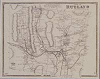
This historical old Rutland map is reproduced from the Atlas of Rutland County, Vermont (VT), published by Beers, Ellis & Soule in 1869.
$15.00 - $21.00
|
|
This historical old Rutland map is reproduced from the Atlas of Rutland County, Vermont (VT), published by Beers, Ellis & Soule in 1869.
$15.00 - $21.00
|
|
This historical old Mendon and Sherburne map is reproduced from the Atlas of Rutland County, Vermont (VT), published by Beers, Ellis & Soule in 1869.
$15.00 - $21.00
|
|
This historical old Benson map is reproduced from the Atlas of Rutland County, Vermont (VT), published by Beers, Ellis & Soule in 1869.
$15.00 - $21.00
|
|
This historical old Hubbardton map is reproduced from the Atlas of Rutland County, Vermont (VT), published by Beers, Ellis & Soule in 1869.
$15.00 - $21.00
|
|
This historical old Pittsford map is reproduced from the Atlas of Rutland County, Vermont (VT), published by Beers, Ellis & Soule in 1869.
$15.00 - $21.00
|
|
This historical old map is reproduced from the Atlas of Rutland County, Vermont (VT), published by Beers, Ellis & Soule in 1869.
$15.00 - $21.00
|
|
|
 Old Maps of New England & New York


