Essex County Maps
Essex County is the only Vermont county for which no county atlas was published. These Essex County maps are reproduced from a wall map ... the Map of the Counties of Orleans, Lamoille and Essex, Vermont, from Actual Surveys under the direction of H. E. Walling, originally published in 1859.
| Products |
|---|
This map shows the northwestern section of Essex County, Vermont. It is reproduced from the 1859 wall map of Orleans, Lamoille & Essex County, Vermont, published by H. F. Walling. This section of the map covers Norton, Warner's Grant, Warren Gore, Avery's Gore, Lewis and Brighton. This map is reproduced in color. $15.00 - $21.00
|
This map shows the northeastern section of Essex County, Vermont. It is reproduced from the 1859 wall map of Orleans, Lamoille & Essex County, Vermont, published by H. F. Walling. This section of the map covers Canaan, Averill, Lemington, Lewis and Bloomfield. This map is reproduced in color.
Please note: Bloomfield is also shown on map VTES03 and Lewis is also shown on map VTES01. $15.00 - $21.00
|
This map shows a section of Essex County, Vermont. It is reproduced from the 1859 wall map of Orleans, Lamoille & Essex County, Vermont, published by H. F. Walling. This section of the map covers the towns of Bloomfield, Brunswick and Ferdinand. This map is reproduced in color.
Please note: Bloomfield is also shown on map VTES03 and Lewis is also shown on map VTES01. $15.00 - $21.00
|
This map shows a section of Essex County, Vermont. It is reproduced from the 1859 wall map of Orleans, Lamoille & Essex County, Vermont, published by H. F. Walling. This section of the map covers the towns of East Haven, Granby and Maidstone. This map is reproduced in color.
Please note: Bloomfield is also shown on map VTES03 and Lewis is also shown on map VTES01. $15.00 - $21.00
|
This map shows a section of Essex County, Vermont. It is reproduced from the 1859 wall map of Orleans, Lamoille & Essex County, Vermont, published by H. F. Walling. This section of the map covers the towns of Granby, Guildhall and Victoroy. This map is reproduced in color.
Please note: Granby is also shown on the map VTES04.
Please note: Bloomfield is also shown on map VTES03 and Lewis is also shown on map VTES01. $15.00 - $21.00
|
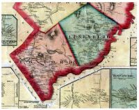
This map shows a section of Essex County, Vermont. It is reproduced from the 1859 wall map of Orleans, Lamoille & Essex County, Vermont, published by H. F. Walling. This section of the map covers the towns of Concord and Lunenburg, with inset maps of the villages of Concord Corners, West Concord and Lunenburg Corners. . This map is reproduced in color.
$15.00 - $21.00
|
|
|
 Old Maps of New England & New York