Old Maps of New England & New York
Historical Ink's Reproductions of antique maps of cities, towns and villages.
Vermont
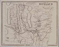
Addison County maps are reproduced from the Atlas of Addison County, published in 1871 by F. W. Beers. Bennington County maps are reproduced from the Atlas of Bennington County, published in 1869 by F. W. Beers. Caledonia County maps are reproduced from the Atlas of Caledonia County, published in 1875 by F. W. Beers. Chittendon County maps are reproduced from the Atlas of Chittenden County, published in 1869 by F. W. Beers. Franklin County maps and Grand Isle County maps are reproduced from the Atlas of Franklin and Grand Isle Counties, published in 1871 by F. W. Beers. Lamoille County maps and Orleans County maps are reproduced from the Atlas of Lamoille & Orleans County, published in 1878 by F. W. Beers. Orange County maps are reproduced from the Atlas of Orange County, published in 1877 by F. W. Beers. Rutland County maps are reproduced from the Atlas of Rutland County, published in 1869 by Beers, Ellis & Soule. Washington County maps are reproduced from the Atlas of Washington County, published in 1873 by F. W. Beers. Windham County maps are reproduced from the Atlas of Windham County, published in 1869 by Beers, Ellis & Soule. Windsor County maps are reproduced from the Atlas of Windsor County, published in 1869 by F. W. Beers.
|