|
This map of is Arkwright is reproduced from the 1867 Atlas of Chautauqua County, New York (NY), by William Stewart
$15.00 - $21.00
|
|
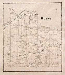
This Busti map is reproduced from the 1867 Atlas of Chautauqua County, New York (NY), by William Stewar
$15.00 - $21.00
|
|
This map is reproduced from the 1867 Atlas of Chautauqua County, New York (NY), by William Stewart
$15.00 - $21.00
|
|
This historical old Carroll map is reproduced from the Atlas of Chautauqua County, New York (NY), published by William Stewart in 1867.
$15.00 - $21.00
|
|
This historical old Charlotte map is reproduced from the Atlas of Chautauqua County, New York (NY), published by William Stewart in 1867.
$15.00 - $21.00
|
|
This historical old Chautauqua map is reproduced from the Atlas of Chautauqua County, New York (NY), published by William Stewart in 1867.
$15.00 - $21.00
|
|
This map is reproduced from the 1867 Atlas of Chautauqua County, New York (NY), by William Stewart
$15.00 - $21.00
|
|
This historical old Cherry Creek map is reproduced from the Atlas of Chautauqua County, New York (NY), published by William Stewart in 1867.
$15.00 - $21.00
|
|
This historical old Clymer map is reproduced from the Atlas of Chautauqua County, New York (NY), published by William Stewart in 1867.
$15.00 - $21.00
|
|
This historical old Dunkirk map is reproduced from the Atlas of Chautauqua County, New York (NY), published by William Stewart in 1867.
$15.00 - $21.00
|
|
This map is reproduced from the 1867 Atlas of Chautauqua County, New York (NY), by William Stewart
$15.00 - $21.00
|
|
This historical old Ellery map is reproduced from the Atlas of Chautauqua County, New York (NY), published by William Stewart in 1867.
$15.00 - $21.00
|
|
This historical old Ellicott map is reproduced from the Atlas of Chautauqua County, New York (NY), published by William Stewart in 1867.
$15.00 - $21.00
|
|
Not available matted. Reproduced from the 1867 Atlas of Chautauqua County
$6.00
|
|
This map is reproduced from the 1867 Atlas of Chautauqua County, New York (NY), by William Stewart
$15.00 - $21.00
|
|
This historical old Jamestown map is reproduced from the Atlas of Chautauqua County, New York (NY), published by William Stewart in 1867.
$15.00 - $21.00
|
|
This historical old Ellington map is reproduced from the Atlas of Chautauqua County, New York (NY), published by William Stewart in 1867.
$15.00 - $21.00
|
|
This historical old French Creek map is reproduced from the Atlas of Chautauqua County, New York (NY), published by William Stewart in 1867.
$15.00 - $21.00
|
|
This historical old Gerry map is reproduced from the Atlas of Chautauqua County, New York (NY), published by William Stewart in 1867.
$15.00 - $21.00
|
|
This map is reproduced from the 1867 Atlas of Chautauqua County, New York (NY), by William Stewart
$15.00 - $21.00
|
|
This map is reproduced from the 1867 Atlas of Chautauqua County, New York (NY), by William Stewart
$15.00 - $21.00
|
|
This map is reproduced from the 1867 Atlas of Chautauqua County, New York (NY), by William Stewart
$15.00 - $21.00
|
|
This historical old Panama village map is reproduced from the Atlas of Chautauqua County, New York (NY), published by William Stewart in 1867.
$15.00 - $21.00
|
|
This historical old Kiantone map is reproduced from the Atlas of Chautauqua County, New York (NY), published by William Stewart in 1867.
$15.00 - $21.00
|
|
This historical old Mina map is reproduced from the Atlas of Chautauqua County, New York (NY), published by William Stewart in 1867.
$15.00 - $21.00
|
|
This historical old Poland map is reproduced from the Atlas of Chautauqua County, New York (NY), published by William Stewart in 1867.
$15.00 - $21.00
|
|
This historical old Pomfret map is reproduced from the Atlas of Chautauqua County, New York (NY), published by William Stewart in 1867.
$15.00 - $21.00
|
|
This historical old Fredonia village map is reproduced from the Atlas of Chautauqua County, New York (NY), published by William Stewart in 1867.
$15.00 - $21.00
|
|
This historical old Portland map is reproduced from the Atlas of Chautauqua County, New York (NY), published by William Stewart in 1867.
$15.00 - $21.00
|
|
This map is reproduced from the 1867 Atlas of Chautauqua County, New York (NY), by William Stewart
$15.00 - $21.00
|
|
This historical old Sheridan map is reproduced from the Atlas of Chautauqua County, New York (NY), published by William Stewart in 1867.
$15.00 - $21.00
|
|
This historical old Sherman map is reproduced from the Atlas of Chautauqua County, New York (NY), published by William Stewart in 1867.
$15.00 - $21.00
|
|
This historical old Stockton map is reproduced from the Atlas of Chautauqua County, New York (NY), published by William Stewart in 1867.
$15.00 - $21.00
|
|
This historical old Villenova map is reproduced from the Atlas of Chautauqua County, New York (NY), published by William Stewart in 1867.
$15.00 - $21.00
|
|
This historical old Westfield map is reproduced from the Atlas of Chautauqua County, New York (NY), published by William Stewart in 1867.
$15.00 - $21.00
|
|
This historical old Westfield village map is reproduced from the Atlas of Chautauqua County, New York (NY), published by William Stewart in 1867.
$15.00 - $21.00
|
|
This historical old Silver Creek village map is reproduced from the Atlas of Chautauqua County, New York (NY), published by William Stewart in 1867.
$15.00 - $21.00
|
|
This historical old Chautauqua County map is reproduced from the Atlas of Chautauqua County, New York (NY), published by William Stewart in 1867.
$15.00 - $21.00
|
 Old Maps of New England & New York