Clinton County Maps
Reproductions of old maps of towns and villages in Clinton County, from the 1869 Atlas of Clinton County, New York, published by F. W. Beers, A. D. Ellis & G. G. Soule.
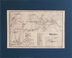
1869 Map of Mooers
Clinton County, NY
| Products |
|---|
|
This historical old map was reproduced from the Atlas of Clinton County, New York (NY), published in 1869 by F. W. Beers, A. D. Ellis & G. G. Soule.
$15.00 - $21.00
|
|
This historical old Clinton map was reproduced from the Atlas of Clinton County, New York (NY), published in 1869 by F. W. Beers, A. D. Ellis & G. G. Soule.
$15.00 - $21.00
|
|
This historical old Mooers map was reproduced from the Atlas of Clinton County, New York (NY), published in 1869 by F. W. Beers, A. D. Ellis & G. G. Soule.
$15.00 - $21.00
|
|
This historical old Champlain map was reproduced from the Atlas of Clinton County, New York (NY), published in 1869 by F. W. Beers, A. D. Ellis & G. G. Soule. (includes Rouses Point)
$15.00 - $21.00
|
|
This historical old Champlain village map was reproduced from the Atlas of Clinton County, New York (NY), published in 1869 by F. W. Beers, A. D. Ellis & G. G. Soule.
$15.00 - $21.00
|
|
This historical old Rouses Point map was reproduced from the Atlas of Clinton County, New York (NY), published in 1869 by F. W. Beers, A. D. Ellis & G. G. Soule.
$15.00 - $21.00
|
|
This historical old Chazy map was reproduced from the Atlas of Clinton County, New York (NY), published in 1869 by F. W. Beers, A. D. Ellis & G. G. Soule.
$15.00 - $21.00
|
|
This historical old Altona map was reproduced from the Atlas of Clinton County, New York (NY), published in 1869 by F. W. Beers, A. D. Ellis & G. G. Soule.
$15.00 - $21.00
|
|
This historical old Ellenburgh map was reproduced from the Atlas of Clinton County, New York (NY), published in 1869 by F. W. Beers, A. D. Ellis & G. G. Soule.
$15.00 - $21.00
|
|
This historical old Dannemore and Saranac map was reproduced from the Atlas of Clinton County, New York (NY), published in 1869 by F. W. Beers, A. D. Ellis & G. G. Soule.
$15.00 - $21.00
|
|
Reproduced from the Atlas of Clinton County, published in 1869 by F. W. Beers, A. D. Ellis & G. G. Soule.
$15.00 - $21.00
|
|
This historical old Russia town map was reproduced from the Atlas of Clinton County, New York (NY), published in 1869 by F. W. Beers, A. D. Ellis & G. G. Soule.
$15.00 - $21.00
|
|
This historical old Black Brook map was reproduced from the Atlas of Clinton County, New York (NY), published in 1869 by F. W. Beers, A. D. Ellis & G. G. Soule.
$15.00 - $21.00
|
|
This historical old Beekmantown map was reproduced from the Atlas of Clinton County, New York (NY), published in 1869 by F. W. Beers, A. D. Ellis & G. G. Soule.
$15.00 - $21.00
|
|
This historical old Plattsburgh and Schuyler Falls map was reproduced from the Atlas of Clinton County, New York (NY), published in 1869 by F. W. Beers, A. D. Ellis & G. G. Soule.
$15.00 - $21.00
|
|
Reproduced from the Atlas of Clinton County, New York (NY), published in 1869 by F. W. Beers, A. D. Ellis & G. G. Soule.
$15.00 - $21.00
|
|
This historical old Peru map was reproduced from the Atlas of Clinton County, New York (NY), published in 1869 by F. W. Beers, A. D. Ellis & G. G. Soule.
$15.00 - $21.00
|
|
This historical old Au Sable map was reproduced from the Atlas of Clinton County, New York (NY), published in 1869 by F. W. Beers, A. D. Ellis & G. G. Soule.
$15.00 - $21.00
|
|
This historical old Keeseville and Clintonville map was reproduced from the Atlas of Clinton County, New York (NY), published in 1869 by F. W. Beers, A. D. Ellis & G. G. Soule.
$15.00 - $21.00
|
|
|
 Old Maps of New England & New York


