Vermont
Reproductions of old maps of towns in Vermont from the county atlases published in the late 1800s.
Addison County maps are reproduced from the Atlas of Addison County, published in 1871 by F. W. Beers.
Bennington County maps are reproduced from the Atlas of Bennington County, published in 1869 by F. W. Beers.
Caledonia County maps are reproduced from the Atlas of Caledonia County, published in 1875 by F. W. Beers.
Chittendon County maps are reproduced from the Atlas of Chittenden County, published in 1869 by F. W. Beers.
Franklin County maps and Grand Isle County maps are reproduced from the Atlas of Franklin and Grand Isle Counties, published in 1871 by F. W. Beers.
Lamoille County maps and Orleans County maps are reproduced from the Atlas of Lamoille & Orleans County, published in 1878 by F. W. Beers.
Orange County maps are reproduced from the Atlas of Orange County, published in 1877 by F. W. Beers.
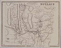
Rutland County maps are reproduced from the Atlas of Rutland County, published in 1869 by Beers, Ellis & Soule.
Washington County maps are reproduced from the Atlas of Washington County, published in 1873 by F. W. Beers.
Windham County maps are reproduced from the Atlas of Windham County, published in 1869 by Beers, Ellis & Soule.
Windsor County maps are reproduced from the Atlas of Windsor County, published in 1869 by F. W. Beers.
| Products |
|---|
|
This historical old Brandon village map is reproduced from the Atlas of Rutland County, Vermont (VT), published by Beers, Ellis & Soule in 1869.
$15.00 - $21.00
|
|
This historical old Brandon map is reproduced from the Atlas of Rutland County, Vermont (VT), published by Beers, Ellis & Soule in 1869.
$15.00 - $21.00
|
|
This historical old Sudbury map is reproduced from the Atlas of Rutland County, Vermont (VT), published by Beers, Ellis & Soule in 1869.
$15.00 - $21.00
|
|
This historical old Chittenden map is reproduced from the Atlas of Rutland County, Vermont (VT), published by Beers, Ellis & Soule in 1869.
$15.00 - $21.00
|
|
This historical old Pittsfield map is reproduced from the Atlas of Rutland County, Vermont (VT), published by Beers, Ellis & Soule in 1869.
$15.00 - $21.00
|
|
This historical old Wallingford and East and South Wallingford map is reproduced from the Atlas of Rutland County, Vermont (VT), published by Beers, Ellis & Soule in 1869.
$15.00 - $21.00
|
|
Washington County map
This historical old Washington County map is reproduced from the Atlas of Washington County, Vermont (VT), published by F. W. Beers in 1873. $15.00 - $21.00
|
|
Woodbury map
This historical old Woodbury map is reproduced from the Atlas of Washington County, Vermont (VT), published by F. W. Beers in 1873. $15.00 - $21.00
|
|
Cabot map
This historical old Cabot map is reproduced from the Atlas of Washington County, Vermont (VT), published by F. W. Beers in 1873. $15.00 - $21.00
|
|
Cabot map
This historical old Cabot and Woodbury map is reproduced from the Atlas of Washington County, Vermont (VT), published by F. W. Beers in 1873. $15.00 - $21.00
|
|
Worcester map
This historical old Worcester map is reproduced from the Atlas of Washington County, Vermont (VT), published by F. W. Beers in 1873. $15.00 - $21.00
|
|
Calais map
This historical old Calais map is reproduced from the Atlas of Washington County, Vermont (VT), published by F. W. Beers in 1873. $15.00 - $21.00
|
|
Marshfield map
This historical old Marshfield map is reproduced from the Atlas of Washington County, Vermont (VT), published by F. W. Beers in 1873. $15.00 - $21.00
|
This historical old map is reproduced from the Atlas of Washington County, Vermont (VT), published by F. W. Beers in 1873. $15.00 - $21.00
|
|
Waterbury map
This historical old Waterbury map is reproduced from the Atlas of Washington County, Vermont (VT), published by F. W. Beers in 1873. $15.00 - $21.00
|
|
Waterbury map
This historical old Waterbury map is reproduced from the Atlas of Washington County, Vermont (VT), published by F. W. Beers in 1873. $15.00 - $21.00
|
This historical old Waterbury Centre map is reproduced from the Atlas of Washington County, Vermont (VT), published by F. W. Beers in 1873. $15.00 - $21.00
|
|
Middlesex map
This historical old Middlesex map is reproduced from the Atlas of Washington County, Vermont (VT), published by F. W. Beers in 1873. $15.00 - $21.00
|
|
Montpelier map
This historical old Montpelier map is reproduced from the Atlas of Washington County, Vermont (VT), published by F. W. Beers in 1873. $15.00 - $21.00
|
This historical old Montpelier map is reproduced from the Atlas of Washington County, Vermont (VT), published by F. W. Beers in 1873. $15.00 - $21.00
|
This historical old Montpelier map is reproduced from the Atlas of Washington County, Vermont (VT), published by F. W. Beers in 1873. $15.00 - $21.00
|
|
East Montpelier map
This historical old East Montpelier map is reproduced from the Atlas of Washington County, Vermont (VT), published by F. W. Beers in 1873. $15.00 - $21.00
|
This historical old map is reproduced from the Atlas of Washington County, Vermont (VT), published by F. W. Beers in 1873. $15.00 - $21.00
|
|
Plainfield map
This historical old Plainfield map is reproduced from the Atlas of Washington County, Vermont (VT), published by F. W. Beers in 1873. $15.00 - $21.00
|
This historical old Goshen and Harris Gores map is reproduced from the Atlas of Washington County, Vermont (VT), published by F. W. Beers in 1873. $15.00 - $21.00
|
|
Duxbury map
This historical old Duxbury map is reproduced from the Atlas of Washington County, Vermont (VT), published by F. W. Beers in 1873. $15.00 - $21.00
|
|
Moretown map
This historical old Moretown map is reproduced from the Atlas of Washington County, Vermont (VT), published by F. W. Beers in 1873. $15.00 - $21.00
|
This historical old map is reproduced from the Atlas of Washington County, Vermont (VT), published by F. W. Beers in 1873. $15.00 - $21.00
|
|
Berlin map
This historical old Berlin map is reproduced from the Atlas of Washington County, Vermont (VT), published by F. W. Beers in 1873. $15.00 - $21.00
|
|
Barre map
This historical old Barre map is reproduced from the Atlas of Washington County, Vermont (VT), published by F. W. Beers in 1873. $15.00 - $21.00
|
|
Fayston map, Waitsfield map
This historical old Waitsfield and Fayston map is reproduced from the Atlas of Washington County, Vermont (VT), published by F. W. Beers in 1873. $15.00 - $21.00
|
|
Northfield map
This historical old Northfield map is reproduced from the Atlas of Washington County, Vermont (VT), published by F. W. Beers in 1873. $15.00 - $21.00
|
This historical old map is reproduced from the Atlas of Washington County, Vermont (VT), published by F. W. Beers in 1873. $15.00 - $21.00
|
This historical old Northfield map is reproduced from the Atlas of Washington County, Vermont (VT), published by F. W. Beers in 1873. $15.00 - $21.00
|
|
Warren map
This historical old Warren map is reproduced from the Atlas of Washington County, Vermont (VT), published by F. W. Beers in 1873. $15.00 - $21.00
|
This historical old map is reproduced from the Atlas of Washington County, Vermont (VT), published by F. W. Beers in 1873. $15.00 - $21.00
|
|
Roxbury map
This historical old Roxbury map is reproduced from the Atlas of Washington County, Vermont (VT), published by F. W. Beers in 1873. $15.00 - $21.00
|
|
Londonderry map
This historical old Londonderry, Vermont map is reproduced from the Atlas of Windham County, Vermont (VT), published by Beers, Ellis & Soule in 1869.
$15.00 - $21.00
|
|
This historical old Londonderry map is reproduced from the Atlas of Windham County, Vermont (VT), published by Beers, Ellis & Soule in 1869.
$15.00 - $21.00
|
|
Windham map
This historical old Windham, Vermont map is reproduced from the Atlas of Windham County, Vermont (VT), published by Beers, Ellis & Soule in 1869.
$15.00 - $21.00
|
|
Grafton map
This historical old Grafton map is reproduced from the Atlas of Windham County, Vermont (VT), published by Beers, Ellis & Soule in 1869.
$15.00 - $21.00
|
|
This historical old WindhamGrafton Center map is reproduced from the Atlas of Windham County, Vermont (VT), published by Beers, Ellis & Soule in 1869.
$15.00 - $21.00
|
|
Rockingham map
This historical old Rockingham, Vermont map is reproduced from the Atlas of Windham County, Vermont (VT), published by Beers, Ellis & Soule in 1869.
$15.00 - $21.00
|
|
Bellows Falls map
This historical old Bellows Falls map is reproduced from the Atlas of Windham County, Vermont (VT), published by Beers, Ellis & Soule in 1869.
$15.00 - $21.00
|
|
Jamaica map
This historical old Jamaica, Vermont map is reproduced from the Atlas of Windham County, Vermont (VT), published by Beers, Ellis & Soule in 1869.
$15.00 - $21.00
|
|
This historical old map is reproduced from the Atlas of Windham County, Vermont (VT), published by Beers, Ellis & Soule in 1869.
$15.00 - $21.00
|
|
Townshend map
This historical old Townshend, Vermont map is reproduced from the Atlas of Windham County, Vermont (VT), published by Beers, Ellis & Soule in 1869.
$15.00 - $21.00
|
|
Athens map, Brookline map
This historical old Athens and Brookline, Vermont map is reproduced from the Atlas of Windham County, Vermont (VT), published by Beers, Ellis & Soule in 1869.
$15.00 - $21.00
|
|
Westminster map
This historical old Westminster, Vermont map is reproduced from the Atlas of Windham County, Vermont (VT), published by Beers, Ellis & Soule in 1869.
$15.00 - $21.00
|
|
Stratton map
This historical old Stratton, Vermont map is reproduced from the Atlas of Windham County, Vermont (VT), published by Beers, Ellis & Soule in 1869.
$15.00 - $21.00
|
|
|
 Old Maps of New England & New York


