|
This historical old cadastral map of Plainfield ws reproduced from the 1871 Beers Atlas of Franklin County, Massachusetts (MA).
$15.00 - $21.00
|
|
This historical old property-owner map of Cummington was reproduced from the 1871 Beers Atlas of Franklin County, Massachusetts (MA).
$15.00 - $21.00
|
|
This historical old landowner map of Chesterfield and Goshen, Massachusetts, was reproduced from the 1871 Beers Atlas of Franklin County, Massachusetts (MA).
$15.00 - $21.00
|
|
This handsome old family-name of Worthington was reproduced from the 1871 Beers Atlas of Franklin County, Massachusetts (MA).
$15.00 - $21.00
|
|
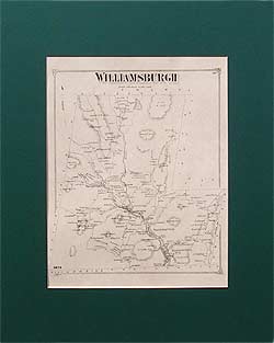
This old familiy-name map of Williamsburgh Massachusetts was reproduced from the 1871 Beers Atlas of Franklin County, Massachusetts (MA).
$15.00 - $21.00
|
|
Reproduced from the 1871 Beers Atlas of Franklin County, Massachusetts (MA).
$15.00 - $21.00
|
|
Reproduced from the 1871 Beers Atlas of Franklin County, Massachusetts (MA).
$15.00 - $21.00
|
|
This historical old family-name map of Hatfield was reproduced from the 1873 Beers Atlas of Hampshire County, Massachusetts (MA).
$15.00 - $21.00
|
|
Reproduced from the 1873 Beers Atlas of Hampshire County, Massachusetts (MA).
$15.00 - $21.00
|
|
This historical old landowner map of Hadley was reproduced from the 1873 Beers Atlas of Hampshire County, Massachusetts (MA).
$15.00 - $21.00
|
|
Reproduced from the 1873 Beers Atlas of Hampshire County, Massachusetts (MA).
$15.00 - $21.00
|
|
This historical old map of the whole town of Amherst was reproduced from the 1873 Beers Atlas of Hampshire County, Massachusetts (MA).
$15.00 - $21.00
|
|
Reproduced from the 1873 Beers Atlas of Hampshire County, Massachusetts (MA).
$15.00 - $21.00
|
|
Reproduced from the 1873 Beers Atlas of Hampshire County, Massachusetts (MA).
$15.00 - $21.00
|
|
Prescott and Pelham landowner map: Reproduced from the 1873 Beers Atlas of Hampshire County, Massachusetts (MA). Prescott is one of the four towns abandoned and flooded for the creation of the Quabbin Reservoir.
$15.00 - $21.00
|
|
This historical old familiy-name map of Middlefield, Massachusetts, was reproduced from the 1873 Beers Atlas of Hampshire County, Massachusetts (MA).
$15.00 - $21.00
|
|
This historical old family-name map of Huntington was reproduced from the 1873 Beers Atlas of Hampshire County, Massachusetts (MA).
$15.00 - $21.00
|
|
Reproduced from the 1873 Beers Atlas of Hampshire County, Massachusetts (MA). Greenwich is one of the four towns abandoned and flooded for the creation of the Quabbin Reservoir.
$15.00 - $21.00
|
|
This historical old family-name map of Westhampton and Southampton was reproduced from the 1873 Beers Atlas of Hampshire County, Massachusetts (MA).
$15.00 - $21.00
|
|
This historical old map shows the entire towns of Northampton and Easthampton, Massachusetts. Reproduced from the 1873 Beers Atlas of Hampshire County, Massachusetts (MA). (For detailed maps of the center of town, see MAHS070 and MAHS74.)
$15.00 - $21.00
|
|
Reproduced from the 1873 Beers Atlas of Hampshire County, Massachusetts (MA). This map shows the northern section of Northampton center.
$15.00 - $21.00
|
|
This historical old map of the southern part of Northampton, Massachusetts, covers the area from the Northampton Lunatic Hospital on the west to Philips Place on the east, from Paradise Road and Park Street on the north, to just below Olive Street on the south side. The Mill River runs through the middle of the map, and the Connecticut River Railway runs through the eastern part of the map. Reproduced from the 1873 Beers Atlas of Hampshire County, Massachusetts (MA).
$15.00 - $21.00
|
|
Reproduced from the 1873 Beers Atlas of Hampshire County, Massachusetts (MA).
$15.00 - $21.00
|
|
Reproduced from the 1873 Beers Atlas of Hampshire County, Massachusetts (MA).
$15.00 - $21.00
|
|
This historical old map of Easthampton center, Massachusetts, was reproduced from the 1873 Beers Atlas of Hampshire County, Massachusetts (MA).
$15.00 - $21.00
|
|
This historical old map of South Hadley, Massachusetts, is reproduced from the 1873 Beers Atlas of Hampshire County, Massachusetts (MA).
$15.00 - $21.00
|
|
Reproduced from the 1873 Beers Atlas of Hampshire County, Massachusetts (MA).
$15.00 - $21.00
|
|
Reproduced from the 1873 Beers Atlas of Hampshire County, Massachusetts (MA).
$15.00 - $21.00
|
|
This historical old family-name map of Granby was reproduced from the 1873 Beers Atlas of Hampshire County, Massachusetts (MA).
$15.00 - $21.00
|
|
This historical old landowner map of Belchertown was reproduced from the 1873 Beers Atlas of Hampshire County, Massachusetts (MA).
$15.00 - $21.00
|
|
This historical old family-name map of Greenwich and Enfield, Massachusetts, was reproduced from the 1873 Beers Atlas of Hampshire County, Massachusetts (MA). Greenwich and Enfield are two of the towns abandoned and flooded for the creation of the Quabbin Reservoir. They are often referred to as the Lost Towns.
$15.00 - $21.00
|
|
Reproduced from the 1873 Beers Atlas of Hampshire County, Massachusetts (MA).
$15.00 - $21.00
|
|
This historical old map of Ware, Massachusetts, was reproduced from the 1873 Beers Atlas of Hampshire County, Massachusetts (MA).
$15.00 - $21.00
|
|
Reproduced from the 1873 Beers Atlas of Hampshire County, Massachusetts (MA).
$15.00 - $21.00
|
 Old Maps of New England & New York