|
Reproduced from the 1875 Beers Atlas of Middlesex County
$15.00 - $21.00
|
|
Lexington map
Historical town map of Lexington, Massachusetts (MA), reproduced from the 1875 Beers Atlas of Middlesex County.
$15.00 - $21.00
|
|
Reproduced from the 1875 Beers Atlas of Middlesex County
$15.00 - $21.00
|
|
Reproduced from the 1875 Beers Atlas of Middlesex County
$15.00 - $21.00
|
|
Winchester map
Historical town map of Winchester, Massachusetts (MA), reproduced from the 1875 Beers Atlas of Middlesex County.
$15.00 - $21.00
|
|
Reproduced from the 1875 Beers Atlas of Middlesex County
$15.00 - $21.00
|
|
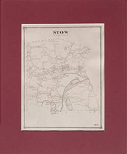
Stow map
Historical town map of Stow, Massachusetts (MA), reproduced from the 1875 Beers Atlas of Middlesex County.
$15.00 - $21.00
|
|
Reproduced from the 1875 Beers Atlas of Middlesex County
$15.00 - $21.00
|
|
Maynard map, Sudbury map
Historical town map of Maynard and Sudbury, Massachusetts (MA), reproduced from the 1875 Beers Atlas of Middlesex County.
$15.00 - $21.00
|
|
Reproduced from the 1875 Beers Atlas of Middlesex County
$15.00 - $21.00
|
|
Reproduced from the 1875 Beers Atlas of Middlesex County
$15.00 - $21.00
|
|
Wayland map
Historical town map of Wayland, Massachusetts (MA), reproduced from the 1875 Beers Atlas of Middlesex County.
$15.00 - $21.00
|
|
Reproduced from the 1875 Beers Atlas of Middlesex County
$15.00 - $21.00
|
|
Weston map
Historical town map of Weston, Massachusetts (MA), reproduced from the 1875 Beers Atlas of Middlesex County.
$15.00 - $21.00
|
|
Waltham map
Historical town map of Waltham, Massachusetts (MA), reproduced from the 1875 Beers Atlas of Middlesex County.
$15.00 - $21.00
|
|
Newton map
Historical town map of Newton, Massachusetts (MA), reproduced from the 1875 Beers Atlas of Middlesex County.
$15.00 - $21.00
|
|
Reproduced from the 1875 Beers Atlas of Middlesex County
$15.00 - $21.00
|
|
This historical old Watertown map is reproduced from the Atlas of Middlesex County, published by F. W. Beers in 1875.
$15.00 - $21.00
|
|
Belmont map
Historical town map of Belmont, Massachusetts (MA), reproduced from the 1875 Beers Atlas of Middlesex County.
$15.00 - $21.00
|
|
Reproduced from the 1875 Beers Atlas of Middlesex County
$15.00 - $21.00
|
|
Arlington map
Historical town map of Arlington, Massachusetts (MA), reproduced from the 1875 Beers Atlas of Middlesex County.
$15.00 - $21.00
|
|
Reproduced from the 1875 Beers Atlas of Middlesex County
$15.00 - $21.00
|
|
Medford map
Historical town map of Medford, Massachusetts (MA), reproduced from the 1875 Beers Atlas of Middlesex County.
$15.00 - $21.00
|
|
Reproduced from the 1875 Beers Atlas of Middlesex County
$15.00 - $21.00
|
|
Reproduced from the 1875 Beers Atlas of Middlesex County
$15.00 - $21.00
|
|
Reproduced from the 1875 Beers Atlas of Middlesex County
$15.00 - $21.00
|
|
Malden map
Historical town map of Malden, Massachusetts (MA), reproduced from the 1875 Beers Atlas of Middlesex County.
$15.00 - $21.00
|
|
Everett map
Historical town map of Everett, Massachusetts (MA), reproduced from the 1875 Beers Atlas of Middlesex County.
$15.00 - $21.00
|
|
Reproduced from the 1875 Beers Atlas of Middlesex County
$15.00 - $21.00
|
|
Historical town map of Sherborn Centre village, Massachusetts (MA), reproduced from the 1875 Beers Atlas of Middlesex County.
$15.00 - $21.00
|
|
Hudson map
Historical town map of Hudson, Massachusetts (MA), reproduced from the 1875 Beers Atlas of Middlesex County.
$15.00 - $21.00
|
|
Reproduced from the 1875 Beers Atlas of Middlesex County
$15.00 - $21.00
|
|
Marlboro map, Marlborough map
Historical town map of Marlborough (Marlboro), Massachusetts (MA), reproduced from the 1875 Beers Atlas of Middlesex County.
$15.00 - $21.00
|
|
Reproduced from the 1875 Beers Atlas of Middlesex County
$15.00 - $21.00
|
|
Framingham map
Historical town map of Framingham, Massachusetts (MA), reproduced from the 1875 Beers Atlas of Middlesex County.
$15.00 - $21.00
|
|
Reproduced from the 1875 Beers Atlas of Middlesex County
$15.00 - $21.00
|
|
Reproduced from the 1875 Beers Atlas of Middlesex County
$15.00 - $21.00
|
|
Natick map
Historical town map of Natick, Massachusetts (MA), reproduced from the 1875 Beers Atlas of Middlesex County.
$15.00 - $21.00
|
|
Reproduced from the 1875 Beers Atlas of Middlesex County
$15.00 - $21.00
|
|
Ashland map, Massachusetts
Historical town map of Ashland, Massachusetts (MA), reproduced from the 1875 Beers Atlas of Middlesex County.
$15.00 - $21.00
|
|
Reproduced from the 1875 Beers Atlas of Middlesex County
$15.00 - $21.00
|
|
Reproduced from the 1875 Beers Atlas of Middlesex County
$15.00 - $21.00
|
|
Hopkinton map, Massachusetts
Historical town map of Hopkinton, Massachusetts (MA), reproduced from the 1875 Beers Atlas of Middlesex County.
$15.00 - $21.00
|
|
Reproduced from the 1875 Beers Atlas of Middlesex County
$15.00 - $21.00
|
|
Reproduced from the 1875 Beers Atlas of Middlesex County
$15.00 - $21.00
|
|
Reproduced from the 1875 Beers Atlas of Middlesex County
$15.00 - $21.00
|
|
Holliston map, Massachusetts
Historical town map of Holliston, Massachusetts (MA), reproduced from the 1875 Beers Atlas of Middlesex County.
$15.00 - $21.00
|
|
Reproduced from the 1875 Beers Atlas of Middlesex County
$15.00 - $21.00
|
|
This old map was drawn to accompany Drake's Old Indian Chronicle, and was compiled chiefly from a Survey of 1774. It shows the areas frequented by the Nipmuck Indians from Sunderland, Vermont on the northwest, to Plaistow, New Hampshire on the northeast; and from Takonik and Sheffield, Massachusetts on the southwest, to Easton, Massachusetts on the southeast. Many brooks and rivers are named. For instance, these are shown feeding into the Connecticut River: Gold River, West River or Wantastitouch River, Whitstone River, Ashuelot River, Bennets River, Stony Branch, Miller River, Papaguntiquash Branch or Millers River, Saw Mill River, Pakumptuk River, Mohawks Branch, Muddy Brook, Mill River, Colemans Brook, Fort Brook, Batchelors Brook, Sawmill Brook, Butter Brook, Willimanset River, Chikabi River, Sunsbank Brook, Long Meadow Brook, Freshwater Brook, Saltonstal, 3 Mile Brook, Agawam River, Parkers, etc.
$15.00 - $21.00
|
|
This map gives a list of names keyed to addresses on the map. (Professors and their residences?)
$15.00 - $21.00
|
 Old Maps of New England & New York