Reproduced from the 1835 print of Captain John Bonner's map originally published in 1722. Shows the "footprint" of all the buildings in Boston. Wharves, hills, and shipyards are located and named. Also shown: rope walks, watch house, burying place, schools, the Common, copper works, and tall ships in the harbor. A chart gives the dates when many buildings were built, and when great fires and small pox epidemics occurred. No family names.
$15.00 - $21.00
|
|
This attractive map shows the streets in Boston, with many buildings identified by a chart. Some adjacent parts of Charlestown, Cambridge, Roxbury, Dorchester and East Boston are shown. No family names.
$15.00 - $21.00
|
|
This map is dedicated ÒTo His Excellency William Burnet, Esq. This Plan of Boston in New England is humbly dedicated to His Excellency - most obedient and humble servant Will Burgis.Ó A chart shows the location of 12 churches, The Town House, Governours House, South Grammar School, South Writing School, North Grammar School, North Writing School, Alms House and Bridewell, as well as the dates of Great Fires. No family names.
$15.00 - $21.00
|
|
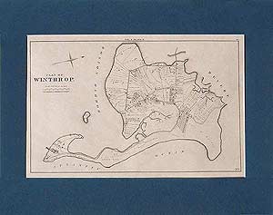
This hand-drawn map of Winthrop, Massachusetts (MA), shows street names, U.S. Mortar Batteries, tracks and stations for the B.W. & S. Railroad. No family names.
$15.00 - $21.00
|
|
Published by J. H. Colton in 1855, this map shows street names in Boston, South Boston, East Boston, Charlestown, Cambridge and Roxbury. Some buildings are identified in Boston (North Market, South Market, Custom House, etc.). No family names.
$15.00 - $21.00
|
|
This map gives a list of names keyed to addresses on the map. (Professors and their residences?)
$15.00 - $21.00
|
|
This reproduction shows the Brighton area from a larger map in the 1889 Atlas. No family names.
$15.00 - $21.00
|
|
Originally published in London November 30, 1781, by J. Bew. This map shows the coast from north of Nahant Point to south of Point Alderton, and west to Roxbury and Dorchester. No family names. No family names.
$15.00 - $21.00
|
|
This is mainly a map of the Boston harbor, the coast and islands from north of Nahant to Rainsford or Hospital Island on the south, with Cambridge and Brookline on the west. No family names.
$15.00 - $21.00
|
|
No family names.
$15.00 - $21.00
|
|
No family names.
$15.00 - $21.00
|
|
Footprints of houses shown but no family names.
$15.00 - $21.00
|
|
1854 Charlestown map (From Felton & Barker's Plan.)
$15.00 - $21.00
|
|
Two small maps from the 1857 "History of South Boston; Formerly Dorchester Neck, now Ward XII of the City of Boston," by Thomas C. Simonds, published in 1857 by David Clapp, over 184 Washington Street, Boston. The two South Boston maps are reproduced on one sheet. The 1775 map is titled "Plan of Dorchester Neck - Drawn for the use of the British Army in 1775." The second map is titled "Plan of South Boston in 1857." The 1857 map shows street names, but no family names. The 1775 map shows the Twin Hills, Harrington's barn, Harrington's House, Dea. Blake's House and Barn, 3 Gun Battery, J. Wiswall's house, Dea. Blake's Orchard, The Barracks afterwards Oliver Wiswell's House, Foster Orchard, Williams' House, Hook or Fosters Hill, Foster House, Nook Lane, Bird House, Farrington's House, etc.
$15.00 - $21.00
|
|
This map is a reproduction of a section of the Map of Water Region Adjacent to Charlestown & Chelsea, showing Route of Charlestown Water Works, signed by C. L. Stevenson, Chief Engineer, February 1865.
$11.00 - $16.00
|
|
From the 1874 Atlas of the County of Suffolk, Volume IV. No family names.
$15.00 - $21.00
|
|
(west of the Boston and Lynn Horse Car Rail Road, Broadway or Salem Turnpike - abutting Malden, Everett, Chelsea and Saugus) Reproduced from the 1874 Atlas of Suffolk County, Volume IV.
$15.00 - $21.00
|
|
(southeast of the Boston and Lynn Horse Car Rail Road, Broadway or Salem Turnpike and showing the parts of Revere that abut the coastline as far north as Atwood Street and on the south to the Winthrop line, BreedÕs Island, and the Chelsea line). Reproduced from the 1874 Atlas of Suffolk County, Volume IV.
$15.00 - $21.00
|
|
(showing the section of Revere from Broadway or Salem Turnpike on the west, with the Pines River and Saugus on the north, Revere Beach on the east, to just south of the Revere Beach Horse Rail Road on the south). Reproduced from the 1874 Atlas of Suffolk County, Volume IV.
$15.00 - $21.00
|
|
This historical old Winthrop map is reproduced from the 1874 Atlas of Suffolk County, Massachusetts (MA), Volume IV.
$15.00 - $21.00
|
|
Reproduced from the 1874 Atlas of Suffolk County, Volume IV. Not available matted.
$15.00
|
|
This historical old map of West Roxbury is reproduced from Volume V of the 1874 Atlas of Suffolk County, Massachusetts (MA). It shows the entire town (including the villages of Roslindale, West Roxbury, Cantrbury, Clarendon Hills, Eggleston Square, Jamaica Plain, Jamaica Pond, Forest Hills Cemetery, Mt. Hope Cemetery, Muddy Pond, Wards Pond, Willow Pond, etc.), with all street names, but has no family names.
$15.00 - $21.00
|
|
An historical old map of Part of West Roxbury (now Ward 17, Boston), reproduced from the 1874 Atlas of Suffolk County, Volume V. Family names shown. This map covers from the Brookline line on the north, to below Jamaica Pond, with Ward 15 on the east and a short distance beyond May Street and Rockwood Street on the west. Streets named are Pond Street, Rockwood Street, Centre Street, Orchard Street, May Street, Perkins Street, Chestnut Street, Prince Street. Jamaica Pond, Ward's Pond and Willow Pond are shown, as well as the Jamaica Ice Co.
$15.00 - $21.00
|
|
Reproduced from the 1874 Atlas of Suffolk County, Volume V. Family names shown.
$15.00 - $21.00
|
These four maps of Boston, Massachusetts (MA), were published in 1905 by the Boston Municipal Printing Office, in a small booklet entitled "Series of Plans of Boston showing Existing Ways and Owners of Property 1630 - 1635 - 1640 - 1645." Compiled by George Lamb, from Town Records, Book of Possessions, Massachusetts (MA) Bay Records, Savage's Winthrop, Lechford's Diary, Aspinwall's Notarial Records and Suffolk County Deeds. Property owners' names are shown as of 1630, 1635, 1640, 1645. Sold as a set only.
The 1630 map shows these owners' names: John Winthrop, Gov., William Coddington, William Balston, Robert Harding, William Brenton, Miles Redding, Robert Sharp, John Underhill, William Cheesebrough, William Blackstone, Edward Gibbons, Revd. John Wilson, Henry Pease, Samuel Cole, John Biggs, James Brown, Thomas Fairweather, John Glover, William Hudson, Jr., Edward Bendell, William Hudson, Sr., Robert Scott, Thomas Matson, James Penn, Zaccheus Bosworth, William Aspinwall, William Colbron, Edward Belcher, William Talmage, Robert Walker, Garret Bourne, John Cranwell, Edward Rainsford, John Odlin, William Lytherland, Giles Firman, John Mills.
The 1635 map lists these owners: names: John Winthrop, Gov., William Coddlington, Wililam Balston, Robert Harding, William Brenton, First Church, Miles Redding, John Underhill, William Blackstone, Richard Bellingham, Thomas Fowle, Edward Gibbons, Atherton Haugh, Rev John Cotton, Robert Keayne, Rev. John Wilson, John Newgate, Daniel Maud, Thomas Oliver, Thomas Leverit, Edmund Jackson, John Mellows, WIlliam Copp, Gabriel Fish, Henry Pease, Walter Merry, John Davies, William Beamsley, James Johnson, Richard Tuttle, John Jackson, John Oliver, Thomas Savage, William Werdall, Edmund Grosse, Samuel Cole, Thomas Marshall, Nathaniel Chappell, James Hawkins, Robert Meeres, Benjamin Thwing, Joshua Scotto, William Wilson, John Biggs, Alexander Beck, James Brown, Thomas Buttolph, Thomas Fairweather, Christopher Stanley, John Glover, Hugh Gunnison, WIlliam Hudson, Jr., George Burden, Sarah Knight, John Button, George Hunne, Nicholas Willis, James Everill, John Coggan, Gov. John Leverit, Edward Bendell, James Oliver, WIlliam Pierce, Isaac Grosse, William Hudson, Jr., Robert Scott, William Parsons, Thomas Matson, James Davis, Richard Fairbanks, William Corser, Philemon Pormot, Richard Truesdale, Robert Turner, Vintner, Richard Hutchinson, Robert Sedgwick, Thomas Scotto, Richard Tappan, Benjamin Gillom, Nathaniel Woodward, John Compton, Edward Hutchinson, Richard Sherman, William Pell, Robert Rice, James Penn, John Kenrick, Nicholas Parker, Nathaniel Bishop, Zaccheus Bosworth, Richard Cooke, William Aspinwall, Thomas Grubb, Edward Jacklin, WIlliam Townsend, Robert Blott, Henry Flint, Anthony Harker, Robert Wing, Ralph Mason, William Colbron, Edard Belcher, William Talmage, Robert Walker, Ralph Roote, Jacob Eliot, WIlliam Salter, Garrett Bourne, John Cranwell, Edard Rainsford, John Odlin, Robert Hull, John Marshall, Richard Waite, Robert Reynolds, Gamaliel Waite, WIlliam Deming, Madid Engles, Rihard Gridley, Edward Brown, William Lytherland, Matthew Iyons, Thomas Munt, Jonathan Negoos, Thomas Foster, George Griggs, Burying Ground, Thomas Peekins, Prison, First School-house
The 1640 map lists these owners' names: John Winthrop, Gov., Robert Harding, William Brenton, First Church, Burying Ground, Thomas Meekins, Prison, First School-house, Richard Peapes, Richard Bellingham, Thomas Fowle, William Hibbins, Edard Gibbons, Atherton Haugh, Rev. John Cotton, Robert Heayne, William Tyng, Rev. John Wilson, Henry Dunster, John Newgate, Daniel Maud, Thomas Oliver, Robert Howen, Thomas Leverit, Edmund Jackson, John Mellows, William Copp, Gabriel Fish, Henry Pease, John Sweete, John Seabury, John Smith, Walter Merry, John Davies, William Beamsley, James Johnson, Richard Tuttle, Bartholomew Cheever, Nehemiah Bourne, John Jackson, Thomas Hawkins, John Oliver, Thomas Savage, William Werdall, Edmund Grosse, Samuel Cole, Thomas Marshall, Thomas Clarke, merchant, John Lowe, Thomas Joy, Richard Raylins, Isaac Cullimore, John Mylom, Francis Hudson, Nathaniel Chappell, Matthew Chaffee, James Hawkins, John Gallop, William Kirkby, Richard Sanford, Robert Meeres, Jeremy Houtchin, Israel Stoughton, Thomas Makepeace, Benjamin Thwing, Joshua Scotto, William Wilson, John Biggs, Alexander Beck, James Brown, Thomas Buttolph, Christopher Stanley, John Glover, Hugh Gunnison, William Hudson, Jr., George Burden, Sarah Knight, Samuel Greames, George Bates, Francis Dowse, John Button, George Hunne, Nicholas Willis, George Barrill, James Everill, Thomas Painter, John Coggan, Gov. John Leverit, William Franklin, Edard Bendell, James Oliver Edward Tyng, William Pierce, David Sellick, Isaac Grosse, WIlliam Davis, Jr., William Hudson, Sr., William Davis, Sr., Robert Scott, William Parsons, Henry Webb, James Davies, Richard Fairbanks, William Corser, Philemon Pormot, Richard Parker, Richard Truesdale, Valentine Hill, Robert Turner, Vintner, Richard Hutchinson, Robert Sedgwick, Thomas Scotto, Henry Messinger, Richard Tapping, Richard Croychley, Benjamin Gillom, Benjamin Ward, Nathaniel Woodward, John Compton, Richard Sherman, William Pell, John Spoore, Robert Rice, John Kenrik, James Penn, Nicholas Parker, Nathaniel Bishop, Zaccheus Bosworth, Richard Cooke, John Lugg, Arthur Perry, Francis Lyle, Thomas Millard, WIlliam Aspinwall, Thomas Grubb, Edmund Dennis, Ephraim Pope, Edard jacklin, William Townsend, Jane Parker, Robert Blott, Henry Flint, Thomas Flint, Anthony Harker, Thomas Clark, blacksmith, Robert Wing, Ralph Mason, Richard Carter, William Colbron, Edward Belher, William Talmage, Robert Walker, Ralph Roote, William Brisco, Jacob Eliot, William Walter, Garret Bourne, John Cranwell, Edard Rainsford, David Offley, Owen Roe, Griffith Bowen, Walter Sinet, John Odlin, Thomas Wheeler, Robert Woodward, John Hurd, William Blantaine, Job Judkins, Robert Hull, mastmaker, John Marshall, Nathaniel Woodward, Richard Hogg, Nathaniel Eaton, Francis East, Richard Waite, Edward Fletcher, Robert Reynolds, John Palmer, Jr., John Palmer, Sr., Gamaliel Waite, Benjamin Negoos, William Deming, Madid Engles, Richard Gridley, Edward Brown, Nicholas Baxter, William Lutherland, Matthw Iyons, Thomas Munt, WIlliam Teft, Jonathan Negoos, Thomas Foster, George Griggs, Richard Woodhouse, Thomas Bell, Richard Hollich.
The 1645 map lists these owners' names: John Winthrop, governor, Robert Harding, William Brenton, First Church, Burying Ground, Thomas Meekins, Prison, First School-house, Richard Peapes, Richard Bellingham, Thomas Fowle, William Hibbins, Edward Gibbins, Atherton Haugh, Rev. John Cotton, Robert Keayne, William Tyng, Rev. John Wilson, Henry Dunster, John Newgate, Daniel Maud, Thomas Oliver, Robert Howen, Nicholas Shapleigh, Thomas Leverit, Edmund Jackson, John Mellows, William Copp, Gabriel Fish, Edward Goodwin, Henry Pease, John Sweete, John Seabury, John Smith, Walter Merry, John Davies, William beamsley, James Johnson, Richard Tuttle, Bartholomew Cheever, Nehemiah Bourne, John Arnold, John Jackson, Thomas Hawkins, John Oliver, Thomas Savage, William Werdall, Edmund Grosse, Samuel Cole, John Hill, blacksmith, Thomas Marshall, Thomas Clarke, merchant, John Lowe, Thomas Joy, Richard Rollins, Henry Symons, Isaac Cullimore, John Mylom, Bartholomew Passmer, David Phippini, Francis Hudson, John Cole, Nathaniel Chappell, Matthew Chaffee, James Hawkins, John Gallop, WIlliam Kirkby, Sampson Shoar, Richard Sanford, Robert meeres, Jeremy Houtchin, Israel Stoughton, Henry Fane, Thomas Makepeace, Benjamin Thwing, Joshua Scotto, William Wilson, John Biggs, Alexander Beck, James Brown, Thomas Hawkins, Thomas Buttolph, Christopher Stanley, John Glover, Hugh Gunnison, William Hudson, Jr., George Burden, Sarah Knight, Samuel Greames, George Bates, Francis Dowse, John BUtton, George Hunne, Nicholas Willis, George Barrill, James Everill, Thomas Painter, John Coggan, Gov. John Leverit, William Franklin, Robert Nash, Edward Bendell, George Foxcraft, James Oliver, Edward Tyng, WIlliam Pierce, David Sellick, Isaac Grosse, William Davis, Jr., WIlliam Hudson, Sr., William Davis, Sr., Robert Scott, William Parsons, Henry Webb, James Davies, Richard Fairbanks, William Corser, Philemon Pormot, Richard Parker, Richard Truesdale, Valentine Hill, Robert Turner, vintner, Richard Hutchinson, Robert Sedgwick, Thomas Scotto, Henry Messinger, Richard Tapping, Richard Croychley, Benjamin Gillom, Benjamin Ward, Nathaniel Woodward, John Compton, Richard Sherman, Edward Hutchinson, William Pell, John Spoore, Robert Rice, William Dinsdale, John Kenrick, James Penn, Nicholas Parker, Nathaniel Bishop, Zaccheus Bosworth, John Stevenson, Richard Cooke, John Synderland, John Lugg, Arthur Perry, Francis Lule, Thomas Millard, William Aspinwall, Thomas Grubb, Edmund Dennis, Ephraim Pope, Edward Jacklin, William Townsend, Jane Parker, Robert Blott, Henry Flint, Thomas Flint, Anthony Harker, Thomas Clark, blacksmith, Ribert Wing, Ralph Mason, Richard Carter, Jacob Leger, William Colbron, Edward Belcher, William Talmage, Robert Walker, Ralph Roote, William Brisco, Jacob Eliot, William Salter, Garret Bourne, John Cranwell, Edawrd Rainsford, David Offley, John Pelton, Griffeth Bowen, Clement Cole, Walter Sinet, John Odlin, Thomaw Wheeler, Robert Woodward, John Hurd, William Blantaine, Job Judkins, Robert Hull, mastmaker, John Marshall, Nathaniel Woodward, Richard Hogg, Nathaniel Eaton, Francis East, Charity White, Richard Waite, Edard Fletcher, Robert Reynolds, John Palmer, Jr., John Palmer, Sr., Amos Richardson, Gamaliel Waite, Benjamin Negoos, WIlliam Deming, Madid Engles, Richard Gridley, John Harrison, Edward Brown, Nicholas Baxter, William Lutherland, Matthew Iyons, Thoms Munt, William Teft, Jonathan Negoos, Thomas Foster, George Griggs, Richard Woodhouse, Thomas Bell, Richard Hollich, Christopher Lawson. $29.00
|
|
 Old Maps of New England & New York