Worcester County Maps
Maps reproduced from the Atlas of Worcester County, Massachusetts, published in 1870 by F. W. Beers.
1870 Map of Dana and Petersham
Worcester County, MA
| Products |
|---|
This broadside was reproduced by the Holden Historical Society, Inc., in 1991, from the original at the American Antiquarian Society in Worcester. The Officers for 1861 include: President, Theron E. Hall; Secretary & Treasurer J. H. Gleason; Standing Committee: A. Putnam, D. F. Parmenter, Ira Broad, Ethan Davis, J. E. Cheney, J. S. Holt, Charles Knowlton, Simon Hubbard and Paul Wadsworth. The Pursuing Committee includes: H. W. Abbott, W. W. Clapp, Sumner Chamberlin, Charles Bryant, S. L. Snow, A. F. Damon, Charles Knowlton, J. B. Jepherson, William H. Drury, P. S. Winn, Amasa Howe, T. E. Hall, Silas Flagg, Jr., Ethan Davis, William H. Walker and Alfred Ladd.
The broadside is dated Holden, Janury 12th, 1861.
Copies are available through the Holden Historical Society, Main Street, Holden, MA 01520 or you may through this web page. $15.00 - $21.00
|
|
This old map was drawn to accompany Drake's Old Indian Chronicle, and was compiled chiefly from a Survey of 1774. It shows the areas frequented by the Nipmuck Indians from Sunderland, Vermont on the northwest, to Plaistow, New Hampshire on the northeast; and from Takonik and Sheffield, Massachusetts on the southwest, to Easton, Massachusetts on the southeast. Many brooks and rivers are named. For instance, these are shown feeding into the Connecticut River: Gold River, West River or Wantastitouch River, Whitstone River, Ashuelot River, Bennets River, Stony Branch, Miller River, Papaguntiquash Branch or Millers River, Saw Mill River, Pakumptuk River, Mohawks Branch, Muddy Brook, Mill River, Colemans Brook, Fort Brook, Batchelors Brook, Sawmill Brook, Butter Brook, Willimanset River, Chikabi River, Sunsbank Brook, Long Meadow Brook, Freshwater Brook, Saltonstal, 3 Mile Brook, Agawam River, Parkers, etc.
$15.00 - $21.00
|
This old Worcester County map is reproduced from the Atlas of Worcester County published in 1870 by F. W. Beers.
$15.00 - $21.00
|
|
Royalston map
This historical old Royalston map was originally published in the Atlas of the Worcester County, Massachusetts (MA), in 1870, by F. W. Beers. $15.00 - $21.00
|
This historical old Winchendon map was originally published in the Atlas of the Worcester County, Massachusetts (MA), in 1870, by F. W. Beers. $15.00 - $21.00
|
|
This historical old map of North Brookfield village is reproduced from the Atlas of Worcester County, published in 1870.
$15.00 - $21.00
|
|
This historical old map of the village of WInchendon is reproduced form the Atlas of Worcester County, published in 1870. Shown are: Millers River ponds, Monadnock Railroad, Station, Freight House, Store House, Sheds, Blacksmith Shop, Baptist Church, Foundry, Machine Shop, Goodspeed & wyman Office, Faucet Factory, North Congregational Church, Bank, Town Hall, School, Old School, Monadnock House, Stable, Sash & BlindSteam Sawmill, Unitarian Church, North School, etc.
$15.00 - $21.00
|
This historical old Winchendon map was originally published in the Atlas of the Worcester County, Massachusetts (MA), in 1870, by F. W. Beers. $15.00 - $21.00
|
|
This historical old map of Fitchburg is a reproduction of the Levi Downe map, published in 1830 by Pendleton's Lithography, Boston, Mass. It includes a list of References, as follows: Numbe of Acres, 17879; Dwelling Houses 325; Meeting-Houses 2; Academy 1; School-Houses 12; Printing Office 1; Woolen Manufacturers 2; Cotton Manufacturers 4; Scythe Manufactory 1; Papermills 2; Gristmills 4; Sawmills 10; Taverns 3; Hat Manufactories 2; Bellows Manufactory 1; Tanneries 2; Windowblind manufacturers 2; Chair Manufactory 1.
$15.00 - $21.00
|
This historical old Ashburnham map was originally published in the Atlas of the Worcester County, Massachusetts (MA), in 1870, by F. W. Beers. $15.00 - $21.00
|
|
Reproduced from the 1870 Atlas of Worcester County by F. W. Beers.
$15.00 - $21.00
|
This historical old Athol map was originally published in the Atlas of the Worcester County, Massachusetts (MA), in 1870, by F. W. Beers. $15.00 - $21.00
|
This historical old Athol village map was originally published in the Atlas of the Worcester County, Massachusetts (MA), in 1870, by F. W. Beers. $15.00 - $21.00
|
|
Phillipston map, Templeton map
This historical old Templeton and Phillipston map was originally published in the Atlas of the Worcester County, Massachusetts (MA), in 1870, by F. W. Beers. $15.00 - $21.00
|
|
Reproduced from the 1870 Atlas of Worcester County by F. W. Beers.
$15.00 - $21.00
|
|
Reproduced from the 1870 Atlas of Worcester County by F. W. Beers.
$15.00 - $21.00
|
|
Gardner map, Gilbertville map
This historical old Gardner and Gilbertville map was originally published in the Atlas of the Worcester County, Massachusetts (MA), in 1870, by F. W. Beers. $15.00 - $21.00
|
|
Reproduced from the 1870 Atlas of Worcester County, Massachusetts (MA) by F. W. Beers.
$15.00 - $21.00
|
This historical old map of Royalston, Massachusetts, was originally published in 1831 by Jonathan Blake Jr., Surveyor. It was "Surveyed and Laid down upon a Scale of 120 Rods to an Inch, in obedience to a Resolve of the General Court, approved by the Governor, March 1, 1830."
The map shows Roads, dwelling houses (with family names), Meeting Houses, Saw Mills, Shingle Mills, Grist Mills, Woolen Factories, Schoolhouses, Tanneries, Store, Cabinet maker Shops, Mountains & Hills, Blacksmiths SHops & Triphammers, Machine Shops, Clothier's Shop, Potash Works, and Forest and Woodland.
$15.00 - $21.00
|
|
Reproduced from the 1870 Atlas of Worcester County, Massachusetts (MA) by F. W. Beers.
$15.00 - $21.00
|
|
Westminster map
This historical old Westminster map was originally published in the Atlas of the Worcester County, Massachusetts (MA), in 1870, by F. W. Beers. $15.00 - $21.00
|
|
Fitchburg map
This historical old Fitchburg map was originally published in the Atlas of the Worcester County, Massachusetts (MA), in 1870, by F. W. Beers. $15.00 - $21.00
|
|
Reproduced from the 1870 Atlas of Worcester County, Massachusetts (MA) by F. W. Beers. This Fitchburg center map shows: Mount Laurel Cemetery, Laurel Hill, Nashua River, Stonemill Pond, Court House, Grammar School, High School, Punch Brook, Rail Road Machine SHops, Saw Mill, Car Shop, Fitchburg Freight Depot, Freight House, Turn Table, Coal Shed, Fitchburg Foundry, Fish Pond, Purifying House, Gas Works, Scales, Hearse House, Dye House, Planing Mill, Putnum Machine Co., etc.
$15.00 - $21.00
|
|
Reproduced from the 1870 Atlas of Worcester County by F. W. Beers.
$15.00 - $21.00
|
|
LUnenburg map
This historical old Lunenburg map was originally published in the Atlas of the Worcester County, Massachusetts (MA), in 1870, by F. W. Beers. $15.00 - $21.00
|
|
Leominster map
This historical old Leominster map was originally published in the Atlas of the Worcester County, Massachusetts (MA), in 1870, by F. W. Beers. $15.00 - $21.00
|
|
Leominster map
This historical old Leominster map was originally published in the Atlas of the Worcester County, Massachusetts (MA), in 1870, by F. W. Beers. $15.00 - $21.00
|
|
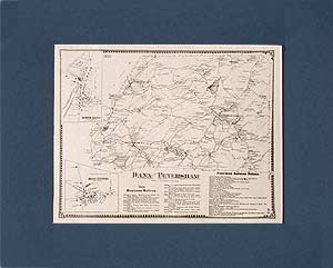
Dana map, Petersham map
This historical old map of Dana and Petersham was reproduced from the 1870 Atlas of Worcester County by F. W. Beers. Dana is one of the four towns abandoned and flooded by the creation of the Quabbin Reservoir. They are often referred to as the Lost Towns of the Quabbin.
$15.00 - $21.00
|
|
Hubbardston map
This historical old Hubbardston map was originally published in 1870 in the Atlas of the Worcester County, Massachusetts (MA), by F. W. Beers. $15.00 - $21.00
|
|
Princeton map
This historical old Princeton map was originally published in 1870 in the Atlas of the Worcester County, Massachusetts (MA), by F. W. Beers. $15.00 - $21.00
|
|
Sterling map
This historical old Sterling map was originally published in 1870 in the Atlas of the Worcester County, Massachusetts (MA), by F. W. Beers. $15.00 - $21.00
|
|
Lancaster map
This historical old Lancaster map was originally published in 1870 in the Atlas of the Worcester County, Massachusetts (MA), by F. W. Beers. $15.00 - $21.00
|
|
Harvard map
This historical old Harvard map was originally published in 1870 in the Atlas of the Worcester County, Massachusetts (MA), by F. W. Beers. $15.00 - $21.00
|
This historical old Bolton and Berlin map was originally published in 1870 in the Atlas of the Worcester County, Massachusetts (MA), by F. W. Beers. $15.00 - $21.00
|
|
Lancaster map
This historical old Lancaster map was originally published in 1870 in the Atlas of the Worcester County, Massachusetts (MA), by F. W. Beers. $15.00 - $21.00
|
|
Hardwick map
This historical old Hardwick map was originally published in 1870 in the Atlas of the Worcester County, Massachusetts (MA), by F. W. Beers. $15.00 - $21.00
|
|
Barre map
This historical old Barre map was originally published in 1870 in the Atlas of the Worcester County, Massachusetts (MA), by F. W. Beers. $15.00 - $21.00
|
|
Reproduced from the 1870 Atlas of Worcester County by F. W. Beers.
$15.00 - $21.00
|
|
Oakham map, New Braintree map
This historical old New Braintree and Oakham map was originally published in 1870 in the Atlas of the Worcester County, Massachusetts (MA), by F. W. Beers. $15.00 - $21.00
|
|
Rutlalnd map
This historical old Rutland map was originally published in 1870 in the Atlas of the Worcester County, Massachusetts (MA), by F. W. Beers. $15.00 - $21.00
|
|
Paxton map, Jefferson map
This historical old Paxton map was originally published in 1870 in the Atlas of the Worcester County, Massachusetts (MA), by F. W. Beers. $15.00 - $21.00
|
|
Holden map
This historical old Holden map was originally published in 1870 in the Atlas of the Worcester County, Massachusetts (MA), by F. W. Beers. $15.00 - $21.00
|
|
Boylston map, West Boylston map
This historical old West Boylston and Boylston map was originally published in 1870 in the Atlas of the Worcester County, Massachusetts (MA), by F. W. Beers. $15.00 - $21.00
|
|
Reproduced from the 1870 Atlas of Worcester County, Massachusetts (MA) by F. W. Beers.
$15.00 - $21.00
|
|
Clinton map
This historical old Clinton map was originally published in 1870 in the Atlas of the Worcester County, Massachusetts (MA), by F. W. Beers. $15.00 - $21.00
|
|
Reproduced from the 1870 Atlas of Worcester County by F. W. Beers. This historical map of Clinton center shows: Passenger Depot, Freight House, Clinton Wire Cloth Co., Machine SHop, Foundry, Lancaster Quilt Company, Counterpane Mill Pond, Lancaster Mills, Tail Race, Carding Spinning & Weaving Room, Dressing Room, Dye House, Feeding Canal, Dam, Franklin Square, Bigelow Carpet Company, Clinton Gas Company, Bank, Bigelow Library and Post Office, Common, Reservoir, Congregational Church, Baptist Church, Grammar School, Store, Clinton Hotel & Hall, etc.
$15.00 - $21.00
|
|
Warren map, West Brookfield map
This historical old Warren and West Brookfield map was originally published in 1870 in the Atlas of the Worcester County, Massachusetts (MA), by F. W. Beers. $15.00 - $21.00
|
|
Reproduced from the 1870 Atlas of Worcester County by F. W. Beers.
$15.00 - $21.00
|
|
North Brookfield map
This historical old North Brookfield map was originally published in 1870 in the Atlas of the Worcester County, Massachusetts (MA), by F. W. Beers. $15.00 - $21.00
|
|
This historical old map of North Brookfield village is reproduced from the Atlas of Worcester County, published in 1870.
$15.00 - $21.00
|
|
|
 Old Maps of New England & New York


